|
|
|||||||||||||||||
| Point ID: 8536 | Downloads | Plots | Site Data | Code: 10694 |
|
|
|||||||||||||||||
| Download | |
|---|---|
| Site Descriptor Information | Site Time Series Data |
| Link to all available data | |
|
|
| View: | Statistics | Time Series |
| Units: | mm |
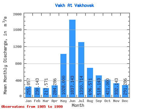
| Statistic | Jan | Feb | Mar | Apr | May | Jun | Jul | Aug | Sep | Oct | Nov | Dec | Annual |
|---|---|---|---|---|---|---|---|---|---|---|---|---|---|
| Mean | 255.86 | 230.14 | 217.57 | 284.29 | 1028.00 | 1837.14 | 1310.71 | 696.57 | 518.14 | 421.00 | 332.14 | 291.29 | 618.57 |
| Standard Deviation | 49.25 | 44.46 | 32.70 | 116.28 | 555.96 | 268.37 | 477.57 | 284.89 | 199.22 | 88.09 | 86.83 | 60.82 | 104.36 |
| Min | 167.00 | 144.00 | 164.00 | 191.00 | 445.00 | 1540.00 | 877.00 | 360.00 | 316.00 | 297.00 | 195.00 | 195.00 | 423.33 |
| Max | 303.00 | 268.00 | 252.00 | 503.00 | 1800.00 | 2300.00 | 2110.00 | 1240.00 | 921.00 | 536.00 | 426.00 | 368.00 | 767.50 |
| Coefficient of Variation | 0.19 | 0.19 | 0.15 | 0.41 | 0.54 | 0.15 | 0.36 | 0.41 | 0.38 | 0.21 | 0.26 | 0.21 | 0.17 |
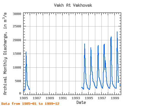
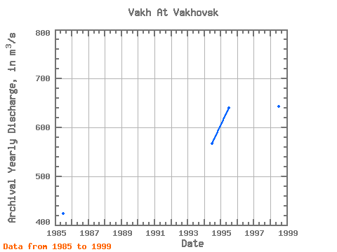
| Year | Jan | Feb | Mar | Apr | May | Jun | Jul | Aug | Sep | Oct | Nov | Dec | Annual | 1985 | 167.00 | 144.00 | 164.00 | 191.00 | 525.00 | 1560.00 | 966.00 | 360.00 | 316.00 | 297.00 | 195.00 | 195.00 | 423.33 | 1994 | 264.00 | 241.00 | 209.00 | 204.00 | 1030.00 | 1850.00 | 1160.00 | 627.00 | 398.00 | 352.00 | 246.00 | 228.00 | 567.42 | 1995 | 210.00 | 196.00 | 187.00 | 388.00 | 1710.00 | 1540.00 | 877.00 | 808.00 | 502.00 | 470.00 | 426.00 | 368.00 | 640.17 | 1996 | 303.00 | 268.00 | 252.00 | 235.00 | 586.00 | 1730.00 | 1800.00 | 649.00 | 597.00 | 504.00 | 422.00 | 331.00 | 639.75 | 1997 | 281.00 | 252.00 | 226.00 | 503.00 | 1800.00 | 1840.00 | 912.00 | 1240.00 | 921.00 | 536.00 | 371.00 | 328.00 | 767.50 | 1998 | 292.00 | 257.00 | 238.00 | 233.00 | 445.00 | 2040.00 | 2110.00 | 735.00 | 403.00 | 359.00 | 315.00 | 288.00 | 642.92 | 1999 | 274.00 | 253.00 | 247.00 | 236.00 | 1100.00 | 2300.00 | 1350.00 | 457.00 | 490.00 | 429.00 | 350.00 | 301.00 | 648.92 |
|---|
 Return to R-Arctic Net Home Page