| Point ID: 8527 | Downloads | Plots | Site Data | Code: 10610 |
| Download | |
|---|---|
| Site Descriptor Information | Site Time Series Data |
| Link to all available data | |

|

|
| View: | Statistics | Time Series |
| Units: | mm |
| Statistic | Jan | Feb | Mar | Apr | May | Jun | Jul | Aug | Sep | Oct | Nov | Dec | Annual |
|---|---|---|---|---|---|---|---|---|---|---|---|---|---|
| Mean | 0.86 | 0.58 | 0.79 | 5.93 | 17.51 | 10.14 | 6.55 | 4.63 | 3.92 | 4.01 | 2.65 | 1.54 | 4.93 |
| Standard Deviation | 0.24 | 0.35 | 0.35 | 3.02 | 4.48 | 5.33 | 2.04 | 1.31 | 1.25 | 0.82 | 0.66 | 0.32 | 1.17 |
| Min | 0.48 | 0.14 | 0.27 | 2.38 | 9.49 | 4.03 | 2.00 | 2.42 | 2.59 | 2.94 | 1.55 | 1.06 | 2.79 |
| Max | 1.21 | 1.25 | 1.39 | 10.70 | 22.80 | 21.90 | 8.92 | 7.18 | 6.29 | 5.06 | 3.70 | 2.06 | 7.08 |
| Coefficient of Variation | 0.28 | 0.60 | 0.45 | 0.51 | 0.26 | 0.53 | 0.31 | 0.28 | 0.32 | 0.20 | 0.25 | 0.21 | 0.24 |
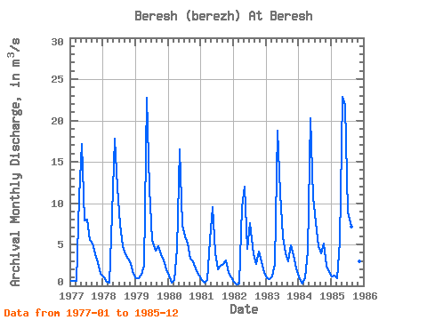
| Year | Jan | Feb | Mar | Apr | May | Jun | Jul | Aug | Sep | Oct | Nov | Dec | Annual | 1977 | 0.58 | 0.64 | 0.58 | 10.70 | 17.20 | 7.90 | 8.02 | 5.50 | 5.09 | 3.86 | 2.83 | 1.46 | 5.36 | 1978 | 1.01 | 0.44 | 0.43 | 8.70 | 17.80 | 11.90 | 7.37 | 4.81 | 3.79 | 3.31 | 2.68 | 1.44 | 5.31 | 1979 | 0.87 | 0.89 | 1.39 | 2.38 | 22.70 | 11.80 | 5.49 | 4.26 | 4.74 | 3.82 | 3.06 | 1.99 | 5.28 | 1980 | 1.21 | 0.36 | 0.72 | 4.44 | 16.50 | 7.40 | 5.93 | 5.06 | 3.29 | 2.94 | 1.78 | 1.23 | 4.24 | 1981 | 0.67 | 0.37 | 0.66 | 5.51 | 9.49 | 4.03 | 2.00 | 2.42 | 2.62 | 3.10 | 1.55 | 1.06 | 2.79 | 1982 | 0.48 | 0.14 | 0.27 | 9.55 | 12.00 | 4.47 | 7.61 | 3.77 | 2.59 | 4.18 | 2.82 | 1.55 | 4.12 | 1983 | 0.95 | 0.80 | 1.12 | 2.65 | 18.80 | 11.20 | 5.95 | 3.91 | 2.93 | 4.91 | 3.70 | 2.06 | 4.92 | 1984 | 0.84 | 0.32 | 1.03 | 4.13 | 20.30 | 10.70 | 7.70 | 4.76 | 3.90 | 5.06 | 2.44 | 1.65 | 5.24 | 1985 | 1.09 | 1.25 | 0.87 | 5.35 | 22.80 | 21.90 | 8.92 | 7.18 | 6.29 | 4.95 | 2.97 | 1.45 | 7.08 |
|---|
 Return to R-Arctic Net Home Page