|
|
|||||||||||||||||
| Point ID: 8520 | Downloads | Plots | Site Data | Code: 10546 |
|
|
|||||||||||||||||
| Download | |
|---|---|
| Site Descriptor Information | Site Time Series Data |
| Link to all available data | |
|
|
| View: | Statistics | Time Series |
| Units: | mm |
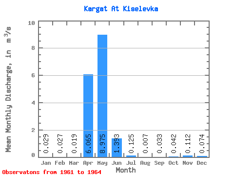
| Statistic | Jan | Feb | Mar | Apr | May | Jun | Jul | Aug | Sep | Oct | Nov | Dec | Annual |
|---|---|---|---|---|---|---|---|---|---|---|---|---|---|
| Mean | 0.03 | 0.03 | 0.02 | 6.07 | 8.97 | 1.39 | 0.12 | 0.01 | 0.03 | 0.04 | 0.11 | 0.07 | 1.15 |
| Standard Deviation | 0.04 | 0.04 | 0.03 | 6.87 | 8.48 | 0.81 | 0.15 | 0.01 | 0.06 | 0.05 | 0.18 | 0.12 | 1.09 |
| Min | 0.00 | 0.00 | 0.00 | 0.40 | 2.58 | 0.36 | 0.01 | 0.00 | 0.00 | 0.00 | 0.00 | 0.00 | 0.34 |
| Max | 0.09 | 0.09 | 0.06 | 16.00 | 20.50 | 2.20 | 0.35 | 0.01 | 0.12 | 0.09 | 0.32 | 0.21 | 2.39 |
| Coefficient of Variation | 1.39 | 1.51 | 1.37 | 1.13 | 0.94 | 0.58 | 1.24 | 0.78 | 1.74 | 1.10 | 1.60 | 1.59 | 0.94 |
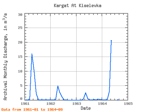
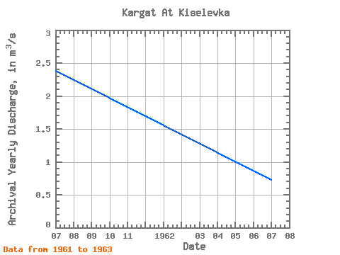
| Year | Jan | Feb | Mar | Apr | May | Jun | Jul | Aug | Sep | Oct | Nov | Dec | Annual | 1961 | 0.03 | 0.02 | 0.02 | 16.00 | 10.20 | 2.20 | 0.10 | 0.01 | 0.01 | 0.04 | 0.02 | 0.01 | 2.39 | 1962 | 0.00 | 0.00 | 0.00 | 4.89 | 2.62 | 1.16 | 0.04 | 0.00 | 0.00 | 0.00 | 0.00 | 0.00 | 0.73 | 1963 | 0.00 | 0.00 | 0.00 | 0.40 | 2.58 | 0.36 | 0.01 | 0.00 | 0.12 | 0.09 | 0.32 | 0.21 | 0.34 | 1964 | 0.09 | 0.09 | 0.06 | 2.97 | 20.50 | 1.85 | 0.35 | 0.01 | 0.01 |
|---|
 Return to R-Arctic Net Home Page