|
|
|||||||||||||||||
| Point ID: 8512 | Downloads | Plots | Site Data | Code: 10487 |
|
|
|||||||||||||||||
| Download | |
|---|---|
| Site Descriptor Information | Site Time Series Data |
| Link to all available data | |
|
|
| View: | Statistics | Time Series |
| Units: | mm |
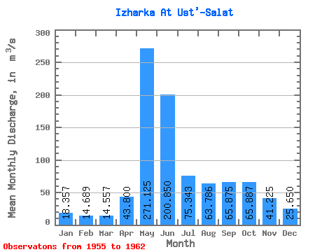
| Statistic | Jan | Feb | Mar | Apr | May | Jun | Jul | Aug | Sep | Oct | Nov | Dec | Annual |
|---|---|---|---|---|---|---|---|---|---|---|---|---|---|
| Mean | 18.36 | 14.69 | 14.56 | 43.80 | 271.12 | 200.85 | 75.34 | 63.79 | 65.88 | 65.89 | 41.23 | 25.65 | 85.49 |
| Standard Deviation | 11.81 | 5.66 | 6.87 | 45.97 | 159.28 | 161.73 | 62.41 | 39.46 | 60.92 | 64.32 | 32.73 | 19.56 | 45.20 |
| Min | 9.40 | 9.02 | 8.00 | 14.30 | 151.00 | 36.50 | 14.00 | 13.20 | 21.60 | 19.60 | 14.10 | 11.80 | 44.32 |
| Max | 44.30 | 26.30 | 29.00 | 153.00 | 573.00 | 558.00 | 203.00 | 116.00 | 181.00 | 194.00 | 93.70 | 67.70 | 163.50 |
| Coefficient of Variation | 0.64 | 0.39 | 0.47 | 1.05 | 0.59 | 0.81 | 0.83 | 0.62 | 0.93 | 0.98 | 0.79 | 0.76 | 0.53 |
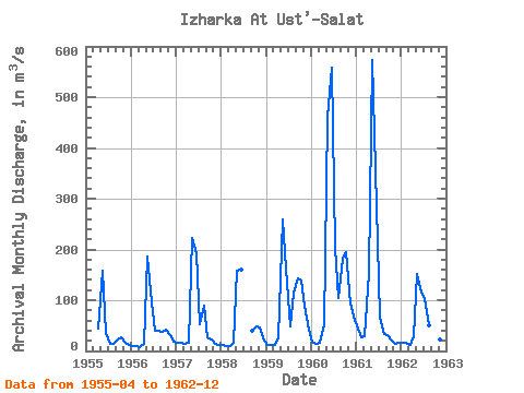
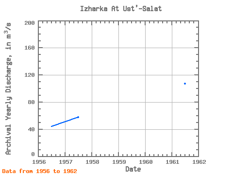
| Year | Jan | Feb | Mar | Apr | May | Jun | Jul | Aug | Sep | Oct | Nov | Dec | Annual | 1955 | 43.80 | 157.00 | 36.50 | 14.00 | 13.20 | 21.60 | 26.60 | 18.50 | 12.40 | 1956 | 9.40 | 9.02 | 8.00 | 14.30 | 186.00 | 95.30 | 40.70 | 39.30 | 38.40 | 41.60 | 30.80 | 19.00 | 44.32 | 1957 | 16.40 | 15.50 | 13.60 | 16.60 | 222.00 | 192.00 | 53.50 | 89.00 | 26.60 | 21.90 | 14.50 | 11.80 | 57.78 | 1958 | 11.70 | 10.60 | 10.50 | 17.00 | 158.00 | 161.00 | 40.40 | 48.10 | 46.30 | 20.20 | 1959 | 12.80 | 12.00 | 12.20 | 27.20 | 260.00 | 163.00 | 47.40 | 116.00 | 144.00 | 138.00 | 89.20 | 42.30 | 88.67 | 1960 | 17.30 | 14.10 | 16.40 | 49.80 | 462.00 | 558.00 | 203.00 | 105.00 | 181.00 | 194.00 | 93.70 | 67.70 | 163.50 | 1961 | 44.30 | 26.30 | 29.00 | 153.00 | 573.00 | 285.00 | 65.80 | 32.70 | 30.30 | 19.60 | 14.10 | 16.20 | 107.44 | 1962 | 16.60 | 15.30 | 12.20 | 28.70 | 151.00 | 116.00 | 103.00 | 51.30 | 44.70 | 37.30 | 22.70 | 15.60 | 51.20 |
|---|
 Return to R-Arctic Net Home Page