|
|
|||||||||||||||||
| Point ID: 8508 | Downloads | Plots | Site Data | Code: 10472 |
|
|
|||||||||||||||||
| Download | |
|---|---|
| Site Descriptor Information | Site Time Series Data |
| Link to all available data | |
|
|
| View: | Statistics | Time Series |
| Units: | mm |
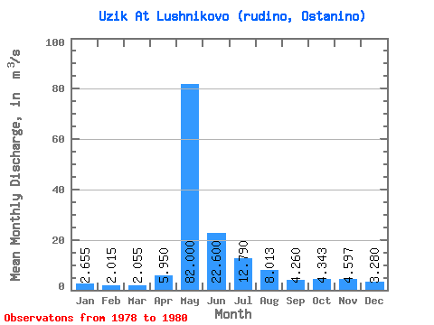
| Statistic | Jan | Feb | Mar | Apr | May | Jun | Jul | Aug | Sep | Oct | Nov | Dec | Annual |
|---|---|---|---|---|---|---|---|---|---|---|---|---|---|
| Mean | 2.66 | 2.02 | 2.06 | 5.95 | 82.00 | 22.60 | 12.79 | 8.01 | 4.26 | 4.34 | 4.60 | 3.28 | 13.48 |
| Standard Deviation | 0.95 | 0.15 | 0.01 | 4.17 | 12.87 | 13.58 | 8.06 | 4.92 | 1.31 | 0.73 | 1.32 | 0.85 | 1.45 |
| Min | 1.98 | 1.91 | 2.05 | 3.00 | 72.90 | 13.00 | 3.57 | 5.15 | 2.85 | 3.57 | 3.43 | 2.64 | 12.46 |
| Max | 3.33 | 2.12 | 2.06 | 8.90 | 91.10 | 32.20 | 18.50 | 13.70 | 5.45 | 5.01 | 6.03 | 4.25 | 14.51 |
| Coefficient of Variation | 0.36 | 0.07 | 0.00 | 0.70 | 0.16 | 0.60 | 0.63 | 0.61 | 0.31 | 0.17 | 0.29 | 0.26 | 0.11 |
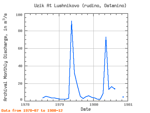
| Year | Jan | Feb | Mar | Apr | May | Jun | Jul | Aug | Sep | Oct | Nov | Dec | Annual | 1978 | 3.57 | 5.15 | 4.48 | 3.57 | 3.43 | 2.64 | 1979 | 1.98 | 1.91 | 2.06 | 3.00 | 91.10 | 32.20 | 18.50 | 5.19 | 2.85 | 5.01 | 6.03 | 4.25 | 14.51 | 1980 | 3.33 | 2.12 | 2.05 | 8.90 | 72.90 | 13.00 | 16.30 | 13.70 | 5.45 | 4.45 | 4.33 | 2.95 | 12.46 |
|---|
 Return to R-Arctic Net Home Page