|
|
|||||||||||||||||
| Point ID: 8491 | Downloads | Plots | Site Data | Code: 10395 |
|
|
|||||||||||||||||
| Download | |
|---|---|
| Site Descriptor Information | Site Time Series Data |
| Link to all available data | |
| View: | Time Series | All |
| Units: | m3/s |
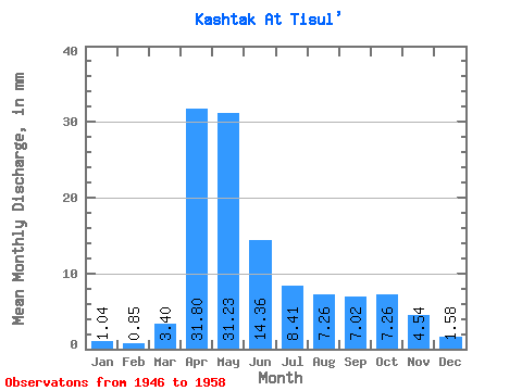
| Statistic | Jan | Feb | Mar | Apr | May | Jun | Jul | Aug | Sep | Oct | Nov | Dec | Annual |
|---|---|---|---|---|---|---|---|---|---|---|---|---|---|
| Mean | 1.05 | 0.86 | 3.41 | 31.80 | 31.23 | 14.36 | 8.40 | 7.25 | 7.03 | 7.26 | 4.54 | 1.58 | 112.76 |
| Standard Deviation | 0.46 | 0.50 | 6.41 | 13.35 | 17.02 | 10.62 | 5.25 | 5.39 | 4.89 | 5.39 | 3.13 | 0.88 | 35.88 |
| Min | 0.24 | 0.12 | 0.07 | 11.40 | 10.98 | 3.89 | 3.75 | 2.17 | 1.71 | 0.40 | 0.43 | 0.54 | 71.31 |
| Max | 1.76 | 1.61 | 23.32 | 58.84 | 67.49 | 31.88 | 20.09 | 21.69 | 20.74 | 21.42 | 13.48 | 3.50 | 175.40 |
| Coefficient of Variation | 0.44 | 0.59 | 1.88 | 0.42 | 0.55 | 0.74 | 0.62 | 0.74 | 0.70 | 0.74 | 0.69 | 0.55 | 0.32 |
 Return to R-Arctic Net Home Page