|
|
|||||||||||||||||
| Point ID: 8490 | Downloads | Plots | Site Data | Code: 10391 |
|
|
|||||||||||||||||
| Download | |
|---|---|
| Site Descriptor Information | Site Time Series Data |
| Link to all available data | |
|
|
| View: | Statistics | Time Series |
| Units: | mm |
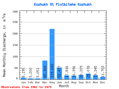
| Statistic | Jan | Feb | Mar | Apr | May | Jun | Jul | Aug | Sep | Oct | Nov | Dec | Annual |
|---|---|---|---|---|---|---|---|---|---|---|---|---|---|
| Mean | 8.20 | 5.20 | 5.05 | 82.16 | 219.65 | 52.48 | 17.82 | 16.40 | 20.21 | 25.08 | 19.34 | 11.70 | 40.47 |
| Standard Deviation | 11.45 | 6.44 | 5.00 | 60.58 | 67.35 | 31.66 | 13.28 | 10.66 | 15.44 | 10.96 | 12.55 | 11.75 | 7.60 |
| Min | 0.65 | 0.64 | 0.80 | 13.30 | 94.80 | 10.50 | 3.85 | 6.16 | 3.88 | 8.14 | 4.22 | 2.38 | 28.29 |
| Max | 36.90 | 23.20 | 18.20 | 199.00 | 303.00 | 112.00 | 40.10 | 40.10 | 57.80 | 39.80 | 50.60 | 37.80 | 52.76 |
| Coefficient of Variation | 1.40 | 1.24 | 0.99 | 0.74 | 0.31 | 0.60 | 0.74 | 0.65 | 0.76 | 0.44 | 0.65 | 1.00 | 0.19 |
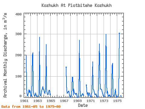
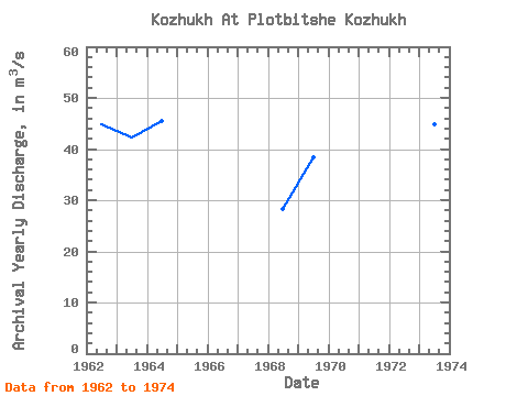
| Year | Jan | Feb | Mar | Apr | May | Jun | Jul | Aug | Sep | Oct | Nov | Dec | Annual | 1961 | 197.00 | 40.30 | 8.61 | 8.28 | 20.00 | 36.70 | 22.00 | 32.00 | 1962 | 20.00 | 5.02 | 5.64 | 199.00 | 211.00 | 34.90 | 14.70 | 6.32 | 8.24 | 21.30 | 7.19 | 4.29 | 44.80 | 1963 | 4.50 | 3.83 | 3.61 | 13.30 | 284.00 | 22.10 | 6.72 | 9.15 | 32.80 | 39.80 | 50.60 | 37.80 | 42.35 | 1964 | 36.90 | 23.20 | 18.20 | 47.80 | 250.00 | 42.20 | 18.30 | 12.70 | 15.40 | 34.10 | 34.20 | 13.90 | 45.58 | 1967 | 143.00 | 57.30 | 19.60 | 20.80 | 27.80 | 29.20 | 9.63 | 2.89 | 1968 | 2.43 | 2.22 | 7.28 | 95.00 | 94.80 | 10.50 | 39.50 | 20.60 | 18.50 | 13.30 | 19.60 | 15.80 | 28.29 | 1969 | 0.65 | 0.64 | 1.11 | 24.40 | 270.00 | 99.50 | 4.35 | 7.16 | 7.55 | 15.30 | 18.30 | 11.40 | 38.36 | 1970 | 57.80 | 14.70 | 21.70 | 4.25 | 22.30 | 19.80 | 6.30 | 1971 | 3.13 | 3.22 | 0.80 | 75.50 | 169.00 | 38.80 | 37.20 | 23.40 | 12.10 | 14.60 | 17.20 | 4.86 | 33.32 | 1972 | 2.64 | 2.53 | 3.08 | 120.00 | 253.00 | 85.40 | 40.10 | 40.10 | 37.60 | 26.40 | 16.70 | 5.62 | 52.76 | 1973 | 4.74 | 4.10 | 4.16 | 80.80 | 299.00 | 67.40 | 19.00 | 29.70 | 3.88 | 8.14 | 12.70 | 3.19 | 44.73 | 1974 | 3.95 | 4.23 | 3.45 | 148.00 | 162.00 | 14.00 | 3.85 | 6.16 | 16.80 | 39.80 | 4.22 | 2.38 | 34.07 | 1975 | 3.01 | 3.01 | 3.18 | 17.80 | 303.00 | 112.00 | 4.97 | 7.08 | 57.80 |
|---|
 Return to R-Arctic Net Home Page