|
|
|||||||||||||||||
| Point ID: 8482 | Downloads | Plots | Site Data | Code: 10322 |
|
|
|||||||||||||||||
| Download | |
|---|---|
| Site Descriptor Information | Site Time Series Data |
| Link to all available data | |
|
|
| View: | Statistics | Time Series |
| Units: | mm |
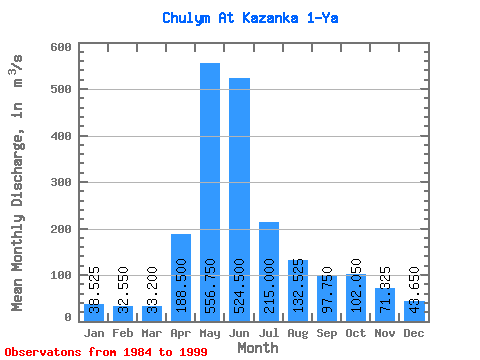
| Statistic | Jan | Feb | Mar | Apr | May | Jun | Jul | Aug | Sep | Oct | Nov | Dec | Annual |
|---|---|---|---|---|---|---|---|---|---|---|---|---|---|
| Mean | 38.52 | 32.55 | 33.20 | 188.50 | 556.75 | 524.50 | 215.00 | 132.53 | 97.75 | 102.05 | 71.33 | 43.65 | 169.69 |
| Standard Deviation | 10.45 | 13.51 | 8.36 | 84.73 | 111.73 | 142.62 | 68.74 | 54.21 | 53.94 | 33.24 | 25.34 | 6.56 | 40.30 |
| Min | 29.00 | 23.60 | 23.90 | 112.00 | 477.00 | 442.00 | 155.00 | 75.10 | 54.20 | 70.70 | 51.30 | 34.80 | 133.41 |
| Max | 52.60 | 52.60 | 44.20 | 301.00 | 721.00 | 737.00 | 289.00 | 198.00 | 172.00 | 136.00 | 106.00 | 50.20 | 219.25 |
| Coefficient of Variation | 0.27 | 0.41 | 0.25 | 0.45 | 0.20 | 0.27 | 0.32 | 0.41 | 0.55 | 0.33 | 0.35 | 0.15 | 0.24 |
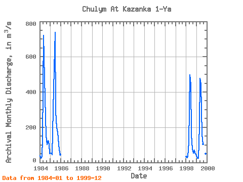
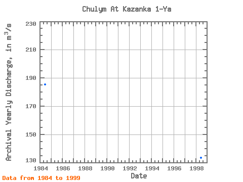
| Year | Jan | Feb | Mar | Apr | May | Jun | Jul | Aug | Sep | Oct | Nov | Dec | Annual | 1984 | 40.00 | 25.60 | 31.70 | 136.00 | 721.00 | 477.00 | 258.00 | 153.00 | 103.00 | 125.00 | 106.00 | 50.20 | 185.54 | 1985 | 52.60 | 52.60 | 44.20 | 301.00 | 531.00 | 737.00 | 289.00 | 198.00 | 172.00 | 136.00 | 74.40 | 43.20 | 219.25 | 1998 | 32.50 | 28.40 | 33.00 | 112.00 | 498.00 | 442.00 | 155.00 | 75.10 | 54.20 | 70.70 | 53.60 | 46.40 | 133.41 | 1999 | 29.00 | 23.60 | 23.90 | 205.00 | 477.00 | 442.00 | 158.00 | 104.00 | 61.80 | 76.50 | 51.30 | 34.80 | 140.57 |
|---|
 Return to R-Arctic Net Home Page