|
|
|||||||||||||||||
| Point ID: 8481 | Downloads | Plots | Site Data | Code: 10321 |
|
|
|||||||||||||||||
| Download | |
|---|---|
| Site Descriptor Information | Site Time Series Data |
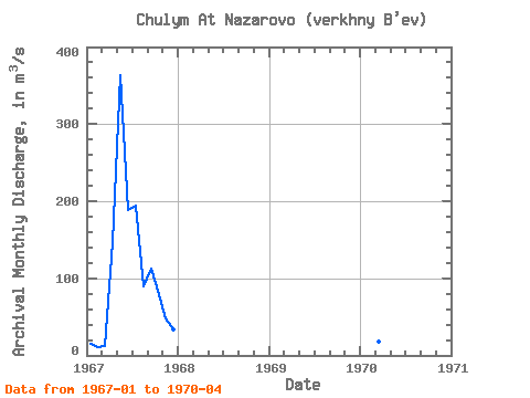
| Link to all available data | |
|
|
| View: | Statistics | Time Series |
| Units: | mm |
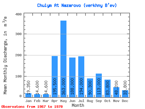
| Statistic | Jan | Feb | Mar | Apr | May | Jun | Jul | Aug | Sep | Oct | Nov | Dec | Annual |
|---|---|---|---|---|---|---|---|---|---|---|---|---|---|
| Mean | 19.35 | 14.60 | 14.60 | 195.50 | 363.00 | 188.00 | 194.00 | 90.30 | 113.00 | 83.80 | 48.20 | 33.80 | 108.20 |
| Standard Deviation | 6.86 | 5.23 | 3.82 | 68.59 | |||||||||
| Min | 14.50 | 10.90 | 11.90 | 147.00 | 363.00 | 188.00 | 194.00 | 90.30 | 113.00 | 83.80 | 48.20 | 33.80 | 108.20 |
| Max | 24.20 | 18.30 | 17.30 | 244.00 | 363.00 | 188.00 | 194.00 | 90.30 | 113.00 | 83.80 | 48.20 | 33.80 | 108.20 |
| Coefficient of Variation | 0.35 | 0.36 | 0.26 | 0.35 |
| Year | Jan | Feb | Mar | Apr | May | Jun | Jul | Aug | Sep | Oct | Nov | Dec | Annual | 1967 | 14.50 | 10.90 | 11.90 | 147.00 | 363.00 | 188.00 | 194.00 | 90.30 | 113.00 | 83.80 | 48.20 | 33.80 | 108.20 | 1970 | 24.20 | 18.30 | 17.30 | 244.00 |
|---|
 Return to R-Arctic Net Home Page