|
|
|||||||||||||||||
| Point ID: 8480 | Downloads | Plots | Site Data | Code: 10320 |
|
|
|||||||||||||||||
| Download | |
|---|---|
| Site Descriptor Information | Site Time Series Data |
| Link to all available data | |
|
|
| View: | Statistics | Time Series |
| Units: | mm |
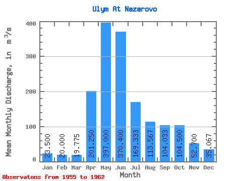
| Statistic | Jan | Feb | Mar | Apr | May | Jun | Jul | Aug | Sep | Oct | Nov | Dec | Annual |
|---|---|---|---|---|---|---|---|---|---|---|---|---|---|
| Mean | 23.50 | 20.00 | 19.77 | 201.25 | 397.00 | 370.40 | 169.33 | 113.57 | 104.03 | 104.50 | 52.70 | 35.07 | 134.06 |
| Standard Deviation | 4.71 | 3.65 | 4.86 | 100.48 | 79.42 | 73.99 | 34.47 | 38.19 | 23.76 | 32.42 | 9.55 | 3.76 | 11.83 |
| Min | 19.70 | 16.40 | 15.20 | 136.00 | 295.00 | 255.00 | 137.00 | 80.00 | 61.00 | 77.00 | 38.40 | 30.00 | 119.46 |
| Max | 30.20 | 23.80 | 24.60 | 349.00 | 489.00 | 458.00 | 228.00 | 188.00 | 126.00 | 154.00 | 63.70 | 40.80 | 146.90 |
| Coefficient of Variation | 0.20 | 0.18 | 0.25 | 0.50 | 0.20 | 0.20 | 0.20 | 0.34 | 0.23 | 0.31 | 0.18 | 0.11 | 0.09 |
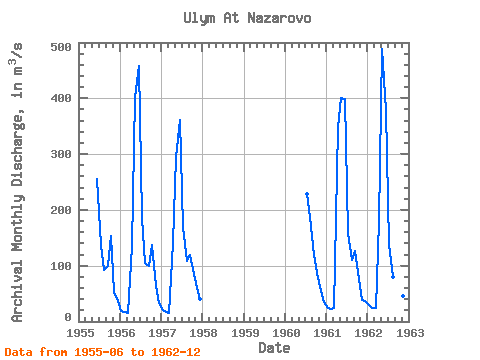
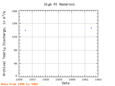
| Year | Jan | Feb | Mar | Apr | May | Jun | Jul | Aug | Sep | Oct | Nov | Dec | Annual | 1955 | 255.00 | 137.00 | 91.40 | 99.20 | 154.00 | 53.30 | 36.60 | 1956 | 19.70 | 17.40 | 16.00 | 136.00 | 403.00 | 458.00 | 186.00 | 104.00 | 100.00 | 137.00 | 63.70 | 32.40 | 139.43 | 1957 | 20.80 | 16.40 | 15.20 | 140.00 | 295.00 | 362.00 | 170.00 | 108.00 | 119.00 | 85.50 | 60.80 | 40.80 | 119.46 | 1960 | 228.00 | 188.00 | 119.00 | 87.50 | 55.00 | 34.20 | 1961 | 23.30 | 22.40 | 23.30 | 349.00 | 401.00 | 398.00 | 158.00 | 110.00 | 126.00 | 77.00 | 38.40 | 36.40 | 146.90 | 1962 | 30.20 | 23.80 | 24.60 | 180.00 | 489.00 | 379.00 | 137.00 | 80.00 | 61.00 | 86.00 | 45.00 | 30.00 | 130.47 |
|---|
 Return to R-Arctic Net Home Page