|
|
|||||||||||||||||
| Point ID: 8465 | Downloads | Plots | Site Data | Code: 10256 |
|
|
|||||||||||||||||
| Download | |
|---|---|
| Site Descriptor Information | Site Time Series Data |
| Link to all available data | |
|
|
| View: | Statistics | Time Series |
| Units: | mm |
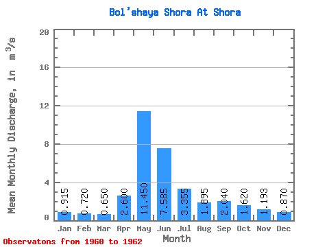
| Statistic | Jan | Feb | Mar | Apr | May | Jun | Jul | Aug | Sep | Oct | Nov | Dec | Annual |
|---|---|---|---|---|---|---|---|---|---|---|---|---|---|
| Mean | 0.92 | 0.72 | 0.65 | 2.60 | 11.45 | 7.58 | 3.35 | 1.90 | 2.04 | 1.62 | 1.19 | 0.87 | 2.94 |
| Standard Deviation | 0.05 | 0.07 | 0.09 | 1.00 | 2.76 | 0.67 | 0.59 | 0.66 | 1.11 | 0.81 | 0.35 | 0.28 | 0.27 |
| Min | 0.88 | 0.67 | 0.59 | 1.89 | 9.50 | 7.11 | 2.94 | 1.43 | 0.96 | 1.15 | 0.91 | 0.62 | 2.75 |
| Max | 0.95 | 0.77 | 0.71 | 3.31 | 13.40 | 8.06 | 3.77 | 2.36 | 3.18 | 2.55 | 1.59 | 1.18 | 3.14 |
| Coefficient of Variation | 0.05 | 0.10 | 0.13 | 0.39 | 0.24 | 0.09 | 0.17 | 0.35 | 0.55 | 0.50 | 0.30 | 0.33 | 0.09 |
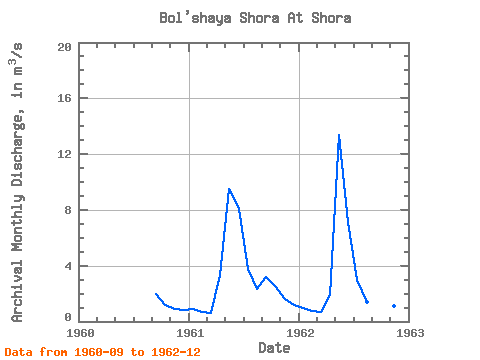
| Year | Jan | Feb | Mar | Apr | May | Jun | Jul | Aug | Sep | Oct | Nov | Dec | Annual | 1960 | 1.98 | 1.15 | 0.91 | 0.81 | 1961 | 0.88 | 0.67 | 0.59 | 3.31 | 9.50 | 8.06 | 3.77 | 2.36 | 3.18 | 2.55 | 1.59 | 1.18 | 3.14 | 1962 | 0.95 | 0.77 | 0.71 | 1.89 | 13.40 | 7.11 | 2.94 | 1.43 | 0.96 | 1.16 | 1.08 | 0.62 | 2.75 |
|---|
 Return to R-Arctic Net Home Page