|
|
|||||||||||||||||
| Point ID: 8464 | Downloads | Plots | Site Data | Code: 10245 |
|
|
|||||||||||||||||
| Download | |
|---|---|
| Site Descriptor Information | Site Time Series Data |
| Link to all available data | |
|
|
| View: | Statistics | Time Series |
| Units: | mm |
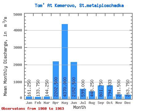
| Statistic | Jan | Feb | Mar | Apr | May | Jun | Jul | Aug | Sep | Oct | Nov | Dec | Annual |
|---|---|---|---|---|---|---|---|---|---|---|---|---|---|
| Mean | 161.25 | 133.75 | 144.25 | 2202.50 | 4370.00 | 2152.50 | 599.00 | 448.25 | 801.75 | 794.33 | 281.50 | 263.75 | 1090.22 |
| Standard Deviation | 18.41 | 9.81 | 9.29 | 1418.01 | 340.98 | 891.19 | 308.55 | 205.46 | 394.30 | 221.86 | 155.09 | 64.06 | 119.30 |
| Min | 142.00 | 126.00 | 131.00 | 970.00 | 3970.00 | 1460.00 | 346.00 | 240.00 | 213.00 | 541.00 | 80.00 | 190.00 | 955.92 |
| Max | 185.00 | 148.00 | 152.00 | 3870.00 | 4770.00 | 3440.00 | 1030.00 | 703.00 | 1050.00 | 954.00 | 435.00 | 343.00 | 1183.92 |
| Coefficient of Variation | 0.11 | 0.07 | 0.06 | 0.64 | 0.08 | 0.41 | 0.52 | 0.46 | 0.49 | 0.28 | 0.55 | 0.24 | 0.11 |
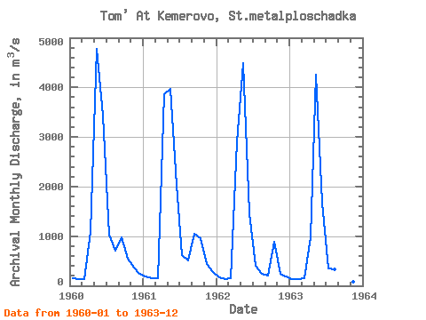
| Year | Jan | Feb | Mar | Apr | May | Jun | Jul | Aug | Sep | Oct | Nov | Dec | Annual | 1960 | 153.00 | 132.00 | 131.00 | 1080.00 | 4770.00 | 3440.00 | 1030.00 | 703.00 | 982.00 | 541.00 | 364.00 | 244.00 | 1130.83 | 1961 | 185.00 | 148.00 | 149.00 | 3870.00 | 3970.00 | 2040.00 | 610.00 | 518.00 | 1050.00 | 954.00 | 435.00 | 278.00 | 1183.92 | 1962 | 165.00 | 126.00 | 152.00 | 2890.00 | 4490.00 | 1460.00 | 410.00 | 240.00 | 213.00 | 888.00 | 247.00 | 190.00 | 955.92 | 1963 | 142.00 | 129.00 | 145.00 | 970.00 | 4250.00 | 1670.00 | 346.00 | 332.00 | 962.00 | 80.00 | 343.00 |
|---|
 Return to R-Arctic Net Home Page