|
|
|||||||||||||||||
| Point ID: 8458 | Downloads | Plots | Site Data | Code: 10224 |
|
|
|||||||||||||||||
| Download | |
|---|---|
| Site Descriptor Information | Site Time Series Data |
| Link to all available data | |
| View: | Time Series | All |
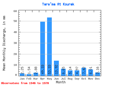
| Units: | m3/s |
| Statistic | Jan | Feb | Mar | Apr | May | Jun | Jul | Aug | Sep | Oct | Nov | Dec | Annual |
|---|---|---|---|---|---|---|---|---|---|---|---|---|---|
| Mean | 2.26 | 1.54 | 2.88 | 49.33 | 53.32 | 13.92 | 6.65 | 5.14 | 4.97 | 7.42 | 6.00 | 3.16 | 160.68 |
| Standard Deviation | 2.49 | 1.71 | 2.96 | 33.50 | 32.12 | 8.19 | 4.39 | 3.57 | 4.27 | 5.29 | 5.77 | 3.17 | 61.37 |
| Min | 0.00 | 0.00 | 0.00 | 4.63 | 11.15 | 4.11 | 1.14 | 1.14 | 1.25 | 1.97 | 0.69 | 0.00 | 65.42 |
| Max | 9.03 | 7.19 | 10.01 | 157.87 | 139.59 | 28.42 | 17.83 | 13.81 | 19.97 | 22.76 | 21.44 | 12.74 | 303.53 |
| Coefficient of Variation | 1.10 | 1.10 | 1.03 | 0.68 | 0.60 | 0.59 | 0.66 | 0.69 | 0.86 | 0.71 | 0.96 | 1.00 | 0.38 |
 Return to R-Arctic Net Home Page