|
|
|||||||||||||||||
| Point ID: 8448 | Downloads | Plots | Site Data | Code: 10183 |
|
|
|||||||||||||||||
| Download | |
|---|---|
| Site Descriptor Information | Site Time Series Data |
| Link to all available data | |
| View: | Time Series | All |
| Units: | mm |
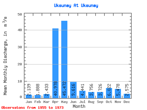
| Statistic | Jan | Feb | Mar | Apr | May | Jun | Jul | Aug | Sep | Oct | Nov | Dec | Annual |
|---|---|---|---|---|---|---|---|---|---|---|---|---|---|
| Mean | 2.14 | 1.89 | 2.43 | 40.98 | 45.47 | 9.62 | 4.44 | 3.76 | 3.73 | 6.02 | 5.48 | 2.58 | 10.70 |
| Standard Deviation | 0.92 | 0.63 | 1.75 | 16.85 | 30.08 | 8.48 | 1.68 | 1.52 | 1.61 | 4.02 | 5.46 | 1.44 | 2.27 |
| Min | 0.73 | 0.89 | 1.10 | 16.20 | 12.40 | 3.33 | 2.21 | 1.83 | 1.66 | 1.78 | 1.75 | 0.97 | 7.21 |
| Max | 4.27 | 3.18 | 9.03 | 79.60 | 122.00 | 40.70 | 7.37 | 6.88 | 7.16 | 18.80 | 24.10 | 7.01 | 14.99 |
| Coefficient of Variation | 0.43 | 0.33 | 0.72 | 0.41 | 0.66 | 0.88 | 0.38 | 0.41 | 0.43 | 0.67 | 1.00 | 0.56 | 0.21 |
 Return to R-Arctic Net Home Page