|
|
|||||||||||||||||
| Point ID: 8448 | Downloads | Plots | Site Data | Code: 10183 |
|
|
|||||||||||||||||
| Download | |
|---|---|
| Site Descriptor Information | Site Time Series Data |
| Link to all available data | |
| View: | Time Series | All |
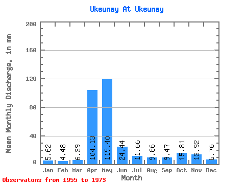
| Units: | m3/s |
| Statistic | Jan | Feb | Mar | Apr | May | Jun | Jul | Aug | Sep | Oct | Nov | Dec | Annual |
|---|---|---|---|---|---|---|---|---|---|---|---|---|---|
| Mean | 5.62 | 4.52 | 6.39 | 104.13 | 119.39 | 24.43 | 11.66 | 9.86 | 9.47 | 15.81 | 13.92 | 6.76 | 331.19 |
| Standard Deviation | 2.41 | 1.51 | 4.58 | 42.82 | 78.98 | 21.56 | 4.42 | 4.00 | 4.10 | 10.55 | 13.87 | 3.77 | 70.36 |
| Min | 1.92 | 2.13 | 2.89 | 41.17 | 32.56 | 8.46 | 5.80 | 4.80 | 4.22 | 4.67 | 4.45 | 2.55 | 223.24 |
| Max | 11.21 | 7.61 | 23.71 | 202.28 | 320.31 | 103.43 | 19.35 | 18.06 | 18.20 | 49.36 | 61.24 | 18.41 | 463.96 |
| Coefficient of Variation | 0.43 | 0.33 | 0.72 | 0.41 | 0.66 | 0.88 | 0.38 | 0.41 | 0.43 | 0.67 | 1.00 | 0.56 | 0.21 |
 Return to R-Arctic Net Home Page