|
|
|||||||||||||||||
| Point ID: 8446 | Downloads | Plots | Site Data | Code: 10178 |
|
|
|||||||||||||||||
| Download | |
|---|---|
| Site Descriptor Information | Site Time Series Data |
| Link to all available data | |
|
|
| View: | Statistics | Time Series |
| Units: | mm |
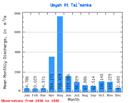
| Statistic | Jan | Feb | Mar | Apr | May | Jun | Jul | Aug | Sep | Oct | Nov | Dec | Annual |
|---|---|---|---|---|---|---|---|---|---|---|---|---|---|
| Mean | 34.79 | 33.03 | 34.97 | 354.17 | 758.43 | 159.09 | 98.93 | 67.89 | 62.51 | 106.14 | 101.23 | 42.68 | 156.53 |
| Standard Deviation | 11.70 | 11.05 | 11.76 | 266.55 | 383.39 | 68.73 | 51.12 | 38.49 | 37.70 | 65.01 | 51.06 | 13.54 | 34.04 |
| Min | 18.20 | 18.50 | 19.90 | 71.20 | 314.00 | 63.60 | 32.70 | 31.30 | 35.00 | 54.10 | 47.90 | 27.10 | 106.43 |
| Max | 54.10 | 52.10 | 52.20 | 744.00 | 1384.00 | 263.00 | 203.00 | 148.00 | 129.00 | 223.00 | 175.00 | 65.40 | 202.01 |
| Coefficient of Variation | 0.34 | 0.34 | 0.34 | 0.75 | 0.51 | 0.43 | 0.52 | 0.57 | 0.60 | 0.61 | 0.50 | 0.32 | 0.22 |
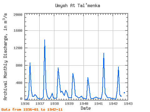
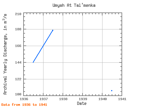
| Year | Jan | Feb | Mar | Apr | May | Jun | Jul | Aug | Sep | Oct | Nov | Dec | Annual | 1936 | 18.20 | 18.50 | 19.90 | 126.00 | 854.00 | 224.00 | 84.00 | 79.80 | 129.00 | 95.50 | 48.00 | 30.60 | 143.96 | 1937 | 25.30 | 26.10 | 28.90 | 71.20 | 1384.00 | 263.00 | 89.50 | 41.20 | 35.30 | 73.40 | 156.00 | 44.90 | 186.57 | 1938 | 39.20 | 40.30 | 52.20 | 744.00 | 456.00 | 175.00 | 203.00 | 148.00 | 103.00 | 223.00 | 175.00 | 65.40 | 202.01 | 1939 | 54.10 | 52.10 | 48.80 | 613.00 | 460.00 | 105.00 | 89.90 | 58.60 | 44.50 | 70.30 | 89.30 | 42.70 | 144.03 | 1940 | 37.10 | 31.30 | 35.50 | 522.00 | 314.00 | 63.60 | 32.70 | 31.30 | 39.80 | 54.10 | 70.40 | 45.40 | 106.43 | 1941 | 40.20 | 36.40 | 33.10 | 187.00 | 1080.00 | 156.00 | 102.00 | 57.20 | 51.00 | 56.70 | 47.90 | 27.10 | 156.22 | 1942 | 29.40 | 26.50 | 26.40 | 216.00 | 761.00 | 127.00 | 91.40 | 59.10 | 35.00 | 170.00 | 122.00 |
|---|
 Return to R-Arctic Net Home Page