|
|
|||||||||||||||||
| Point ID: 8430 | Downloads | Plots | Site Data | Code: 10102 |
|
|
|||||||||||||||||
| Download | |
|---|---|
| Site Descriptor Information | Site Time Series Data |
| Link to all available data | |
|
|
| View: | Statistics | Time Series |
| Units: | mm |
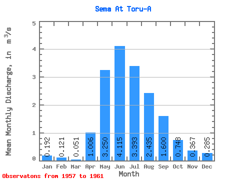
| Statistic | Jan | Feb | Mar | Apr | May | Jun | Jul | Aug | Sep | Oct | Nov | Dec | Annual |
|---|---|---|---|---|---|---|---|---|---|---|---|---|---|
| Mean | 0.19 | 0.12 | 0.05 | 1.01 | 3.25 | 4.12 | 3.39 | 2.44 | 1.60 | 0.75 | 0.37 | 0.28 | 1.64 |
| Standard Deviation | 0.17 | 0.11 | 0.05 | 0.55 | 1.06 | 1.89 | 2.43 | 0.87 | 0.59 | 0.28 | 0.14 | 0.16 | 0.59 |
| Min | 0.05 | 0.03 | 0.01 | 0.54 | 2.51 | 2.34 | 1.67 | 1.51 | 0.76 | 0.37 | 0.18 | 0.08 | 1.14 |
| Max | 0.38 | 0.24 | 0.11 | 1.92 | 5.11 | 6.79 | 7.00 | 3.41 | 2.12 | 1.03 | 0.50 | 0.46 | 2.29 |
| Coefficient of Variation | 0.89 | 0.90 | 1.03 | 0.55 | 0.33 | 0.46 | 0.72 | 0.36 | 0.37 | 0.37 | 0.37 | 0.57 | 0.36 |
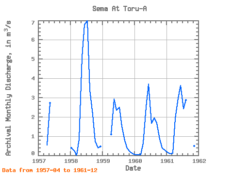
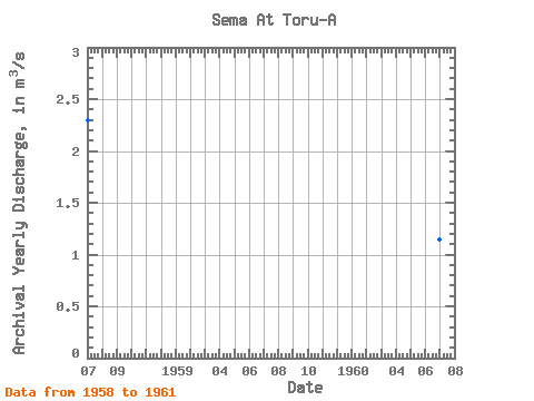
| Year | Jan | Feb | Mar | Apr | May | Jun | Jul | Aug | Sep | Oct | Nov | Dec | Annual | 1957 | 0.54 | 2.73 | 1958 | 0.38 | 0.24 | 0.01 | 0.85 | 5.11 | 6.79 | 7.00 | 3.41 | 2.12 | 0.74 | 0.39 | 0.46 | 2.29 | 1959 | 1.09 | 2.93 | 2.34 | 2.49 | 1.51 | 0.76 | 0.37 | 0.18 | 0.08 | 1960 | 0.05 | 0.03 | 0.04 | 0.63 | 2.51 | 3.70 | 1.67 | 1.94 | 1.66 | 0.85 | 0.40 | 0.25 | 1.14 | 1961 | 0.15 | 0.09 | 0.11 | 1.92 | 2.97 | 3.63 | 2.41 | 2.88 | 1.86 | 1.03 | 0.50 | 0.35 | 1.49 |
|---|
 Return to R-Arctic Net Home Page