|
|
|||||||||||||||||
| Point ID: 8423 | Downloads | Plots | Site Data | Code: 10092 |
|
|
|||||||||||||||||
| Download | |
|---|---|
| Site Descriptor Information | Site Time Series Data |
| Link to all available data | |
|
|
| View: | Statistics | Time Series |
| Units: | mm |
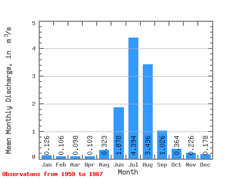
| Statistic | Jan | Feb | Mar | Apr | May | Jun | Jul | Aug | Sep | Oct | Nov | Dec | Annual |
|---|---|---|---|---|---|---|---|---|---|---|---|---|---|
| Mean | 0.13 | 0.11 | 0.10 | 0.10 | 0.32 | 1.88 | 4.39 | 3.44 | 1.03 | 0.36 | 0.23 | 0.18 | 0.99 |
| Standard Deviation | 0.03 | 0.02 | 0.02 | 0.02 | 0.16 | 0.39 | 0.92 | 0.61 | 0.52 | 0.07 | 0.04 | 0.04 | 0.14 |
| Min | 0.09 | 0.07 | 0.08 | 0.08 | 0.07 | 1.31 | 3.28 | 2.74 | 0.48 | 0.26 | 0.18 | 0.13 | 0.88 |
| Max | 0.15 | 0.13 | 0.12 | 0.12 | 0.47 | 2.26 | 5.50 | 4.41 | 1.72 | 0.47 | 0.28 | 0.23 | 1.20 |
| Coefficient of Variation | 0.23 | 0.20 | 0.17 | 0.18 | 0.50 | 0.21 | 0.21 | 0.18 | 0.51 | 0.21 | 0.20 | 0.23 | 0.15 |
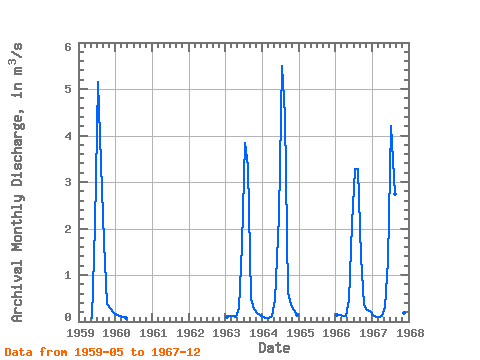
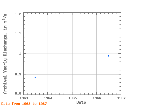
| Year | Jan | Feb | Mar | Apr | May | Jun | Jul | Aug | Sep | Oct | Nov | Dec | Annual | 1959 | 0.07 | 2.07 | 5.15 | 3.41 | 1.72 | 0.38 | 0.28 | 0.21 | 1960 | 0.15 | 0.12 | 0.09 | 0.08 | 1963 | 0.10 | 0.11 | 0.12 | 0.09 | 0.30 | 1.65 | 3.84 | 3.34 | 0.48 | 0.26 | 0.18 | 0.13 | 0.88 | 1964 | 0.09 | 0.07 | 0.08 | 0.12 | 0.47 | 2.26 | 5.50 | 4.41 | 0.61 | 0.36 | 0.24 | 0.15 | 1.20 | 1966 | 0.15 | 0.13 | 0.11 | 0.12 | 0.46 | 2.10 | 3.28 | 3.28 | 1.39 | 0.35 | 0.25 | 0.23 | 0.99 | 1967 | 0.14 | 0.10 | 0.09 | 0.11 | 0.31 | 1.31 | 4.20 | 2.74 | 0.93 | 0.47 | 0.18 | 0.17 | 0.90 |
|---|
 Return to R-Arctic Net Home Page