|
|
|||||||||||||||||
| Point ID: 8382 | Downloads | Plots | Site Data | Code: 9467 |
|
|
|||||||||||||||||
| Download | |
|---|---|
| Site Descriptor Information | Site Time Series Data |
| Link to all available data | |
|
|
| View: | Statistics | Time Series |
| Units: | mm |
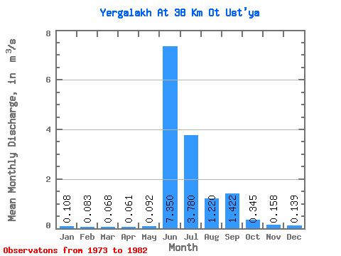
| Statistic | Jan | Feb | Mar | Apr | May | Jun | Jul | Aug | Sep | Oct | Nov | Dec | Annual |
|---|---|---|---|---|---|---|---|---|---|---|---|---|---|
| Mean | 0.11 | 0.08 | 0.07 | 0.06 | 0.09 | 7.35 | 3.78 | 1.22 | 1.42 | 0.34 | 0.16 | 0.14 | 1.31 |
| Standard Deviation | 0.12 | 0.09 | 0.08 | 0.08 | 0.12 | 4.74 | 2.26 | 0.84 | 0.47 | 0.20 | 0.16 | 0.15 | 0.15 |
| Min | 0.00 | 0.00 | 0.00 | 0.00 | 0.00 | 0.00 | 1.88 | 0.30 | 1.08 | 0.09 | 0.00 | 0.00 | 1.16 |
| Max | 0.24 | 0.19 | 0.16 | 0.20 | 0.28 | 13.40 | 7.64 | 2.14 | 2.11 | 0.52 | 0.33 | 0.30 | 1.49 |
| Coefficient of Variation | 1.10 | 1.12 | 1.11 | 1.31 | 1.27 | 0.64 | 0.60 | 0.69 | 0.33 | 0.57 | 1.01 | 1.10 | 0.12 |
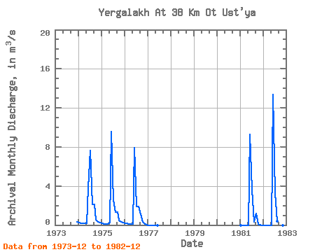
| Year | Jan | Feb | Mar | Apr | May | Jun | Jul | Aug | Sep | Oct | Nov | Dec | Annual | 1973 | 0.30 | 1974 | 0.24 | 0.19 | 0.16 | 0.20 | 0.18 | 3.85 | 7.64 | 2.14 | 2.11 | 0.52 | 0.33 | 0.27 | 1.49 | 1975 | 0.20 | 0.13 | 0.12 | 0.08 | 0.28 | 9.60 | 2.52 | 1.32 | 1.33 | 0.48 | 0.31 | 0.26 | 1.39 | 1976 | 0.21 | 0.18 | 0.13 | 0.08 | 0.09 | 7.94 | 1.88 | 1.92 | 1.08 | 0.29 | 0.15 | 0.00 | 1.16 | 1977 | 0.00 | 0.00 | 0.00 | 0.00 | 0.00 | 0.00 | 1981 | 0.00 | 0.00 | 0.00 | 0.00 | 0.00 | 9.31 | 3.61 | 0.30 | 1.17 | 0.09 | 0.00 | 0.00 | 1.21 | 1982 | 0.00 | 0.00 | 0.00 | 0.00 | 0.00 | 13.40 | 3.25 | 0.42 | 0.00 | 0.00 |
|---|
 Return to R-Arctic Net Home Page