|
|
|||||||||||||||||
| Point ID: 8379 | Downloads | Plots | Site Data | Code: 9461 |
|
|
|||||||||||||||||
| Download | |
|---|---|
| Site Descriptor Information | Site Time Series Data |
| Link to all available data | |
|
|
| View: | Statistics | Time Series |
| Units: | mm |
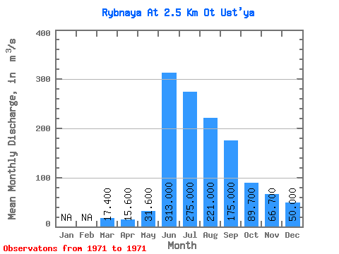
| Statistic | Jan | Feb | Mar | Apr | May | Jun | Jul | Aug | Sep | Oct | Nov | Dec | Annual |
|---|---|---|---|---|---|---|---|---|---|---|---|---|---|
| Mean | 17.40 | 15.60 | 31.60 | 313.00 | 275.00 | 221.00 | 175.00 | 89.70 | 66.70 | 50.00 | |||
| Standard Deviation | |||||||||||||
| Min | 17.40 | 15.60 | 31.60 | 313.00 | 275.00 | 221.00 | 175.00 | 89.70 | 66.70 | 50.00 | |||
| Max | 17.40 | 15.60 | 31.60 | 313.00 | 275.00 | 221.00 | 175.00 | 89.70 | 66.70 | 50.00 | |||
| Coefficient of Variation |
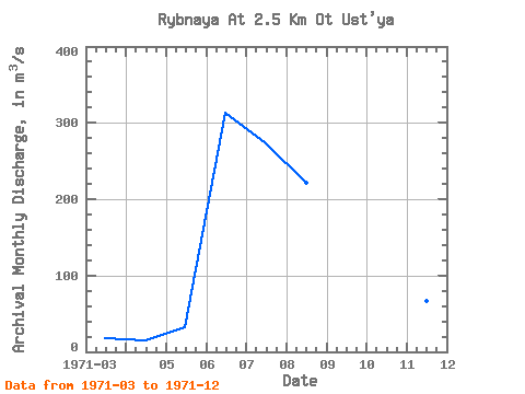
| Year | Jan | Feb | Mar | Apr | May | Jun | Jul | Aug | Sep | Oct | Nov | Dec | Annual | 1971 | 17.40 | 15.60 | 31.60 | 313.00 | 275.00 | 221.00 | 175.00 | 89.70 | 66.70 | 50.00 |
|---|
 Return to R-Arctic Net Home Page