|
|
|||||||||||||||||
| Point ID: 8347 | Downloads | Plots | Site Data | Code: 9311 |
|
|
|||||||||||||||||
| Download | |
|---|---|
| Site Descriptor Information | Site Time Series Data |
| Link to all available data | |
| View: | Time Series | All |
| Units: | m3/s |
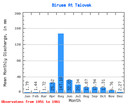
| Statistic | Jan | Feb | Mar | Apr | May | Jun | Jul | Aug | Sep | Oct | Nov | Dec | Annual |
|---|---|---|---|---|---|---|---|---|---|---|---|---|---|
| Mean | 1.79 | 1.45 | 1.73 | 25.52 | 147.08 | 32.03 | 20.34 | 13.87 | 13.94 | 13.30 | 6.76 | 2.27 | 272.72 |
| Standard Deviation | 0.62 | 0.49 | 0.83 | 25.66 | 26.78 | 21.28 | 15.10 | 11.97 | 12.68 | 10.56 | 6.94 | 0.69 | 48.71 |
| Min | 0.62 | 0.45 | 0.56 | 2.21 | 116.35 | 9.06 | 4.49 | 4.25 | 4.17 | 4.12 | 1.61 | 0.99 | 211.61 |
| Max | 2.77 | 2.08 | 3.33 | 85.21 | 212.39 | 76.87 | 45.80 | 44.08 | 44.75 | 34.84 | 25.21 | 3.27 | 363.87 |
| Coefficient of Variation | 0.35 | 0.34 | 0.48 | 1.00 | 0.18 | 0.66 | 0.74 | 0.86 | 0.91 | 0.79 | 1.03 | 0.30 | 0.18 |
 Return to R-Arctic Net Home Page