|
|
|||||||||||||||||
| Point ID: 8331 | Downloads | Plots | Site Data | Code: 9287 |
|
|
|||||||||||||||||
| Download | |
|---|---|
| Site Descriptor Information | Site Time Series Data |
| Link to all available data | |
|
|
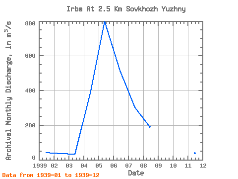
| View: | Statistics | Time Series |
| Units: | mm |
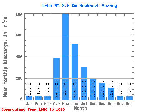
| Statistic | Jan | Feb | Mar | Apr | May | Jun | Jul | Aug | Sep | Oct | Nov | Dec | Annual |
|---|---|---|---|---|---|---|---|---|---|---|---|---|---|
| Mean | 40.90 | 34.70 | 31.90 | 382.00 | 799.00 | 516.00 | 302.00 | 190.00 | 159.00 | 112.00 | 39.50 | 32.50 | 219.96 |
| Standard Deviation | |||||||||||||
| Min | 40.90 | 34.70 | 31.90 | 382.00 | 799.00 | 516.00 | 302.00 | 190.00 | 159.00 | 112.00 | 39.50 | 32.50 | 219.96 |
| Max | 40.90 | 34.70 | 31.90 | 382.00 | 799.00 | 516.00 | 302.00 | 190.00 | 159.00 | 112.00 | 39.50 | 32.50 | 219.96 |
| Coefficient of Variation |
| Year | Jan | Feb | Mar | Apr | May | Jun | Jul | Aug | Sep | Oct | Nov | Dec | Annual | 1939 | 40.90 | 34.70 | 31.90 | 382.00 | 799.00 | 516.00 | 302.00 | 190.00 | 159.00 | 112.00 | 39.50 | 32.50 | 219.96 |
|---|
 Return to R-Arctic Net Home Page