|
|
|||||||||||||||||
| Point ID: 8312 | Downloads | Plots | Site Data | Code: 9195 |
|
|
|||||||||||||||||
| Download | |
|---|---|
| Site Descriptor Information | Site Time Series Data |
| Link to all available data | |
|
|
| View: | Statistics | Time Series |
| Units: | mm |
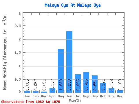
| Statistic | Jan | Feb | Mar | Apr | May | Jun | Jul | Aug | Sep | Oct | Nov | Dec | Annual |
|---|---|---|---|---|---|---|---|---|---|---|---|---|---|
| Mean | 0.07 | 0.06 | 0.05 | 0.18 | 1.63 | 2.30 | 0.69 | 0.77 | 0.65 | 0.37 | 0.18 | 0.10 | 0.57 |
| Standard Deviation | 0.04 | 0.03 | 0.04 | 0.23 | 0.80 | 1.77 | 0.37 | 0.34 | 0.14 | 0.12 | 0.05 | 0.04 | 0.13 |
| Min | 0.03 | 0.03 | 0.02 | 0.03 | 0.44 | 0.75 | 0.30 | 0.18 | 0.47 | 0.24 | 0.11 | 0.06 | 0.39 |
| Max | 0.14 | 0.13 | 0.13 | 0.74 | 2.47 | 5.02 | 1.35 | 1.37 | 0.90 | 0.57 | 0.28 | 0.15 | 0.78 |
| Coefficient of Variation | 0.54 | 0.55 | 0.68 | 1.33 | 0.49 | 0.77 | 0.53 | 0.45 | 0.22 | 0.31 | 0.27 | 0.35 | 0.23 |
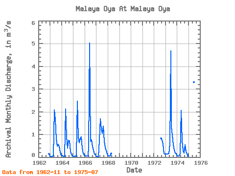
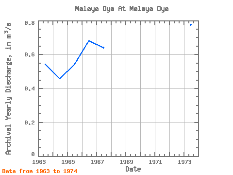
| Year | Jan | Feb | Mar | Apr | May | Jun | Jul | Aug | Sep | Oct | Nov | Dec | Annual | 1962 | 0.17 | 0.09 | 1963 | 0.04 | 0.04 | 0.04 | 0.05 | 2.08 | 1.64 | 0.81 | 0.48 | 0.57 | 0.47 | 0.22 | 0.08 | 0.54 | 1964 | 0.07 | 0.06 | 0.02 | 0.03 | 2.11 | 0.89 | 0.40 | 0.75 | 0.73 | 0.24 | 0.11 | 0.06 | 0.46 | 1965 | 0.04 | 0.04 | 0.05 | 0.04 | 2.47 | 0.87 | 0.64 | 0.80 | 0.90 | 0.39 | 0.17 | 0.09 | 0.54 | 1966 | 0.07 | 0.06 | 0.05 | 0.06 | 0.44 | 5.02 | 0.70 | 0.76 | 0.47 | 0.30 | 0.15 | 0.09 | 0.68 | 1967 | 0.03 | 0.03 | 0.02 | 0.74 | 1.68 | 1.24 | 1.04 | 1.37 | 0.70 | 0.43 | 0.28 | 0.15 | 0.64 | 1968 | 0.06 | 0.05 | 0.05 | 0.17 | 1972 | 0.83 | 0.77 | 0.57 | 0.17 | 0.14 | 1973 | 0.14 | 0.13 | 0.13 | 0.17 | 0.57 | 4.67 | 1.35 | 0.96 | 0.54 | 0.32 | 0.18 | 0.14 | 0.78 | 1974 | 0.08 | 0.06 | 0.05 | 0.15 | 2.06 | 0.75 | 0.30 | 0.18 | 0.55 | 0.25 | 0.15 | 0.06 | 0.39 | 1975 | 3.31 | 0.32 |
|---|
 Return to R-Arctic Net Home Page