|
|
|||||||||||||||||
| Point ID: 8285 | Downloads | Plots | Site Data | Code: 9035 |
|
|
|||||||||||||||||
| Download | |
|---|---|
| Site Descriptor Information | Site Time Series Data |
| Link to all available data | |
|
|
| View: | Statistics | Time Series |
| Units: | mm |
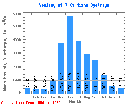
| Statistic | Jan | Feb | Mar | Apr | May | Jun | Jul | Aug | Sep | Oct | Nov | Dec | Annual |
|---|---|---|---|---|---|---|---|---|---|---|---|---|---|
| Mean | 415.86 | 358.86 | 348.14 | 938.00 | 3752.86 | 5701.43 | 3871.43 | 2915.71 | 2465.71 | 1387.14 | 587.71 | 449.71 | 1932.71 |
| Standard Deviation | 52.58 | 45.60 | 59.75 | 433.90 | 771.96 | 809.39 | 930.49 | 618.68 | 401.87 | 120.65 | 68.61 | 42.09 | 233.08 |
| Min | 341.00 | 278.00 | 272.00 | 636.00 | 2790.00 | 4440.00 | 2560.00 | 2260.00 | 1810.00 | 1270.00 | 526.00 | 378.00 | 1701.25 |
| Max | 470.00 | 406.00 | 439.00 | 1900.00 | 5010.00 | 6640.00 | 4960.00 | 3770.00 | 2930.00 | 1630.00 | 722.00 | 492.00 | 2317.92 |
| Coefficient of Variation | 0.13 | 0.13 | 0.17 | 0.46 | 0.21 | 0.14 | 0.24 | 0.21 | 0.16 | 0.09 | 0.12 | 0.09 | 0.12 |
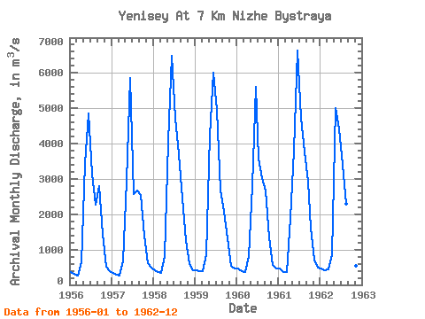
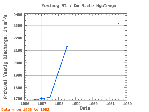
| Year | Jan | Feb | Mar | Apr | May | Jun | Jul | Aug | Sep | Oct | Nov | Dec | Annual | 1956 | 358.00 | 325.00 | 272.00 | 636.00 | 3430.00 | 4860.00 | 3140.00 | 2260.00 | 2790.00 | 1440.00 | 526.00 | 378.00 | 1701.25 | 1957 | 341.00 | 278.00 | 273.00 | 670.00 | 2950.00 | 5860.00 | 2560.00 | 2670.00 | 2550.00 | 1390.00 | 624.00 | 483.00 | 1720.75 | 1958 | 404.00 | 358.00 | 344.00 | 815.00 | 4050.00 | 6490.00 | 4720.00 | 3710.00 | 2440.00 | 1270.00 | 591.00 | 406.00 | 2133.17 | 1959 | 411.00 | 401.00 | 382.00 | 868.00 | 4230.00 | 6010.00 | 4960.00 | 2680.00 | 2060.00 | 1320.00 | 549.00 | 469.00 | 2028.33 | 1960 | 463.00 | 387.00 | 357.00 | 813.00 | 2790.00 | 5610.00 | 3580.00 | 3020.00 | 2680.00 | 1350.00 | 572.00 | 467.00 | 1840.75 | 1961 | 464.00 | 357.00 | 370.00 | 1900.00 | 3810.00 | 6640.00 | 4730.00 | 3770.00 | 2930.00 | 1630.00 | 722.00 | 492.00 | 2317.92 | 1962 | 470.00 | 406.00 | 439.00 | 864.00 | 5010.00 | 4440.00 | 3410.00 | 2300.00 | 1810.00 | 1310.00 | 530.00 | 453.00 | 1786.83 |
|---|
 Return to R-Arctic Net Home Page