|
|
|||||||||||||||||
| Point ID: 8282 | Downloads | Plots | Site Data | Code: 9012 |
|
|
|||||||||||||||||
| Download | |
|---|---|
| Site Descriptor Information | Site Time Series Data |
| Link to all available data | |
|
|
| View: | Statistics | Time Series |
| Units: | mm |
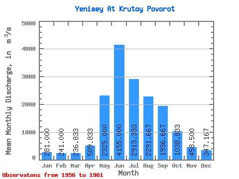
| Statistic | Jan | Feb | Mar | Apr | May | Jun | Jul | Aug | Sep | Oct | Nov | Dec | Annual |
|---|---|---|---|---|---|---|---|---|---|---|---|---|---|
| Mean | 281.00 | 241.00 | 236.83 | 509.83 | 2325.00 | 4155.00 | 2913.33 | 2291.67 | 1936.67 | 1038.83 | 458.50 | 347.17 | 1394.57 |
| Standard Deviation | 31.17 | 29.41 | 27.14 | 226.49 | 424.20 | 357.59 | 775.47 | 465.08 | 174.20 | 49.84 | 52.21 | 40.94 | 169.17 |
| Min | 235.00 | 206.00 | 205.00 | 368.00 | 1760.00 | 3560.00 | 1770.00 | 1780.00 | 1640.00 | 988.00 | 410.00 | 282.00 | 1213.83 |
| Max | 312.00 | 287.00 | 271.00 | 963.00 | 2830.00 | 4470.00 | 3670.00 | 2890.00 | 2120.00 | 1120.00 | 546.00 | 393.00 | 1601.25 |
| Coefficient of Variation | 0.11 | 0.12 | 0.12 | 0.44 | 0.18 | 0.09 | 0.27 | 0.20 | 0.09 | 0.05 | 0.11 | 0.12 | 0.12 |
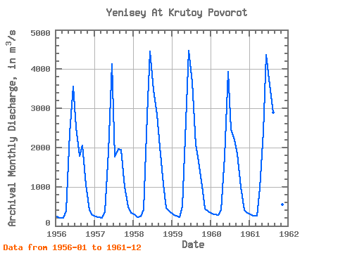
| Year | Jan | Feb | Mar | Apr | May | Jun | Jul | Aug | Sep | Oct | Nov | Dec | Annual | 1956 | 249.00 | 206.00 | 205.00 | 394.00 | 2380.00 | 3560.00 | 2510.00 | 1780.00 | 2060.00 | 1040.00 | 410.00 | 282.00 | 1256.33 | 1957 | 235.00 | 220.00 | 211.00 | 368.00 | 1890.00 | 4130.00 | 1770.00 | 1970.00 | 1950.00 | 995.00 | 490.00 | 337.00 | 1213.83 | 1958 | 298.00 | 226.00 | 246.00 | 423.00 | 2830.00 | 4460.00 | 3470.00 | 2840.00 | 2010.00 | 1070.00 | 456.00 | 375.00 | 1558.67 | 1959 | 293.00 | 255.00 | 226.00 | 501.00 | 2680.00 | 4470.00 | 3670.00 | 2070.00 | 1640.00 | 1020.00 | 437.00 | 372.00 | 1469.50 | 1960 | 312.00 | 287.00 | 271.00 | 410.00 | 1760.00 | 3940.00 | 2470.00 | 2200.00 | 1840.00 | 988.00 | 412.00 | 324.00 | 1267.83 | 1961 | 299.00 | 252.00 | 262.00 | 963.00 | 2410.00 | 4370.00 | 3590.00 | 2890.00 | 2120.00 | 1120.00 | 546.00 | 393.00 | 1601.25 |
|---|
 Return to R-Arctic Net Home Page