|
|
|||||||||||||||||
| Point ID: 8280 | Downloads | Plots | Site Data | Code: 8409 |
|
|
|||||||||||||||||
| Download | |
|---|---|
| Site Descriptor Information | Site Time Series Data |
| Link to all available data | |
|
|
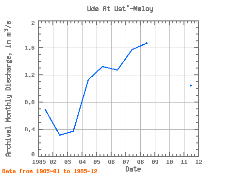
| View: | Statistics | Time Series |
| Units: | mm |
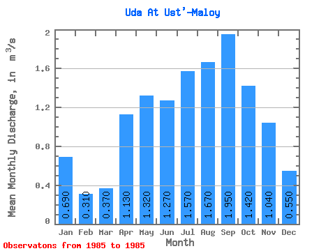
| Statistic | Jan | Feb | Mar | Apr | May | Jun | Jul | Aug | Sep | Oct | Nov | Dec | Annual |
|---|---|---|---|---|---|---|---|---|---|---|---|---|---|
| Mean | 0.69 | 0.31 | 0.37 | 1.13 | 1.32 | 1.27 | 1.57 | 1.67 | 1.95 | 1.42 | 1.04 | 0.55 | 1.11 |
| Standard Deviation | |||||||||||||
| Min | 0.69 | 0.31 | 0.37 | 1.13 | 1.32 | 1.27 | 1.57 | 1.67 | 1.95 | 1.42 | 1.04 | 0.55 | 1.11 |
| Max | 0.69 | 0.31 | 0.37 | 1.13 | 1.32 | 1.27 | 1.57 | 1.67 | 1.95 | 1.42 | 1.04 | 0.55 | 1.11 |
| Coefficient of Variation |
| Year | Jan | Feb | Mar | Apr | May | Jun | Jul | Aug | Sep | Oct | Nov | Dec | Annual | 1985 | 0.69 | 0.31 | 0.37 | 1.13 | 1.32 | 1.27 | 1.57 | 1.67 | 1.95 | 1.42 | 1.04 | 0.55 | 1.11 |
|---|
 Return to R-Arctic Net Home Page