|
|
|||||||||||||||||
| Point ID: 8257 | Downloads | Plots | Site Data | Code: 8354 |
|
|
|||||||||||||||||
| Download | |
|---|---|
| Site Descriptor Information | Site Time Series Data |
| Link to all available data | |
|
|
| View: | Statistics | Time Series |
| Units: | mm |
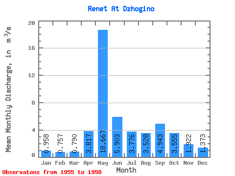
| Statistic | Jan | Feb | Mar | Apr | May | Jun | Jul | Aug | Sep | Oct | Nov | Dec | Annual |
|---|---|---|---|---|---|---|---|---|---|---|---|---|---|
| Mean | 0.96 | 0.76 | 0.79 | 3.82 | 18.67 | 5.90 | 3.78 | 3.53 | 4.94 | 3.56 | 1.92 | 1.37 | 3.54 |
| Standard Deviation | 0.25 | 0.17 | 0.20 | 1.18 | 8.83 | 1.06 | 3.34 | 2.37 | 5.27 | 2.57 | 0.60 | 0.41 | 0.81 |
| Min | 0.67 | 0.59 | 0.61 | 2.46 | 10.30 | 4.73 | 1.81 | 1.49 | 1.70 | 1.75 | 1.48 | 0.94 | 2.80 |
| Max | 1.21 | 0.96 | 1.07 | 4.58 | 27.90 | 7.29 | 8.76 | 6.95 | 12.80 | 7.29 | 2.80 | 1.84 | 4.41 |
| Coefficient of Variation | 0.26 | 0.22 | 0.25 | 0.31 | 0.47 | 0.18 | 0.88 | 0.67 | 1.07 | 0.72 | 0.31 | 0.30 | 0.23 |
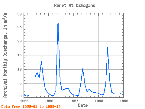
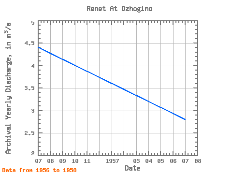
| Year | Jan | Feb | Mar | Apr | May | Jun | Jul | Aug | Sep | Oct | Nov | Dec | Annual | 1955 | 0.67 | 0.83 | 0.75 | 7.29 | 8.76 | 6.95 | 12.80 | 7.29 | 2.80 | 1.84 | 1956 | 1.12 | 0.59 | 0.73 | 2.46 | 27.90 | 5.67 | 2.54 | 2.84 | 3.14 | 3.22 | 1.75 | 0.94 | 4.41 | 1957 | 0.83 | 0.65 | 0.61 | 4.58 | 10.30 | 4.73 | 1.99 | 2.83 | 2.13 | 1.75 | 1.66 | 1.57 | 2.80 | 1958 | 1.21 | 0.96 | 1.07 | 4.41 | 17.80 | 5.92 | 1.81 | 1.49 | 1.70 | 1.96 | 1.48 | 1.14 | 3.41 |
|---|
 Return to R-Arctic Net Home Page