|
|
|||||||||||||||||
| Point ID: 8251 | Downloads | Plots | Site Data | Code: 8338 |
|
|
|||||||||||||||||
| Download | |
|---|---|
| Site Descriptor Information | Site Time Series Data |
| Link to all available data | |
|
|
| View: | Statistics | Time Series |
| Units: | mm |
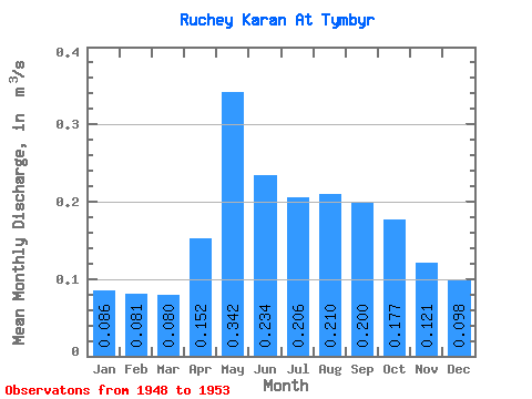
| Statistic | Jan | Feb | Mar | Apr | May | Jun | Jul | Aug | Sep | Oct | Nov | Dec | Annual |
|---|---|---|---|---|---|---|---|---|---|---|---|---|---|
| Mean | 0.09 | 0.08 | 0.08 | 0.15 | 0.34 | 0.23 | 0.21 | 0.21 | 0.20 | 0.18 | 0.12 | 0.10 | 0.17 |
| Standard Deviation | 0.02 | 0.02 | 0.01 | 0.14 | 0.24 | 0.19 | 0.08 | 0.09 | 0.07 | 0.08 | 0.05 | 0.03 | 0.07 |
| Min | 0.06 | 0.06 | 0.06 | 0.00 | 0.00 | 0.00 | 0.14 | 0.12 | 0.12 | 0.11 | 0.08 | 0.06 | 0.09 |
| Max | 0.12 | 0.10 | 0.09 | 0.39 | 0.59 | 0.51 | 0.33 | 0.33 | 0.32 | 0.33 | 0.21 | 0.15 | 0.26 |
| Coefficient of Variation | 0.25 | 0.20 | 0.17 | 0.94 | 0.70 | 0.80 | 0.37 | 0.41 | 0.37 | 0.46 | 0.41 | 0.32 | 0.42 |
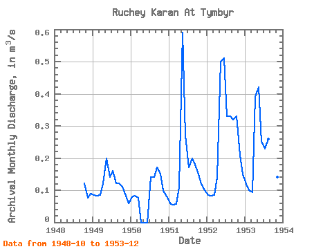
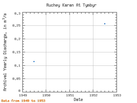
| Year | Jan | Feb | Mar | Apr | May | Jun | Jul | Aug | Sep | Oct | Nov | Dec | Annual | 1948 | 0.12 | 0.08 | 0.09 | 1949 | 0.09 | 0.08 | 0.08 | 0.12 | 0.20 | 0.14 | 0.16 | 0.12 | 0.12 | 0.11 | 0.08 | 0.06 | 0.11 | 1950 | 0.08 | 0.08 | 0.08 | 0.00 | 0.00 | 0.00 | 0.14 | 0.14 | 0.17 | 0.15 | 0.10 | 0.08 | 0.09 | 1951 | 0.06 | 0.06 | 0.06 | 0.11 | 0.59 | 0.27 | 0.17 | 0.20 | 0.18 | 0.15 | 0.12 | 0.10 | 0.17 | 1952 | 0.09 | 0.08 | 0.09 | 0.14 | 0.50 | 0.51 | 0.33 | 0.33 | 0.32 | 0.33 | 0.21 | 0.15 | 0.26 | 1953 | 0.12 | 0.10 | 0.09 | 0.39 | 0.42 | 0.25 | 0.23 | 0.26 | 0.21 | 0.20 | 0.14 | 0.11 | 0.21 |
|---|
 Return to R-Arctic Net Home Page