|
|
|||||||||||||||||
| Point ID: 8249 | Downloads | Plots | Site Data | Code: 8333 |
|
|
|||||||||||||||||
| Download | |
|---|---|
| Site Descriptor Information | Site Time Series Data |
| Link to all available data | |
|
|
| View: | Statistics | Time Series |
| Units: | mm |
| Statistic | Jan | Feb | Mar | Apr | May | Jun | Jul | Aug | Sep | Oct | Nov | Dec | Annual |
|---|---|---|---|---|---|---|---|---|---|---|---|---|---|
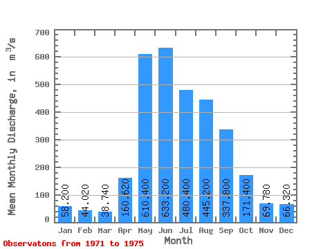
| Mean | 58.20 | 44.02 | 38.74 | 160.62 | 610.40 | 633.20 | 480.40 | 445.20 | 337.80 | 171.40 | 69.78 | 66.32 | 259.67 |
| Standard Deviation | 8.23 | 6.00 | 5.71 | 86.24 | 238.09 | 327.12 | 157.96 | 177.46 | 104.85 | 27.45 | 10.97 | 18.81 | 51.32 |
| Min | 47.70 | 35.30 | 34.40 | 42.10 | 339.00 | 337.00 | 258.00 | 221.00 | 259.00 | 142.00 | 58.40 | 50.10 | 181.28 |
| Max | 70.50 | 50.10 | 47.70 | 242.00 | 931.00 | 1110.00 | 654.00 | 717.00 | 516.00 | 208.00 | 86.10 | 96.60 | 322.57 |
| Coefficient of Variation | 0.14 | 0.14 | 0.15 | 0.54 | 0.39 | 0.52 | 0.33 | 0.40 | 0.31 | 0.16 | 0.16 | 0.28 | 0.20 |
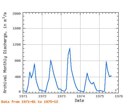
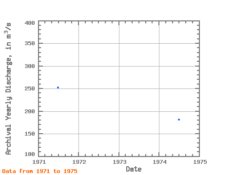
| Year | Jan | Feb | Mar | Apr | May | Jun | Jul | Aug | Sep | Oct | Nov | Dec | Annual | 1971 | 56.50 | 41.40 | 35.60 | 178.00 | 517.00 | 366.00 | 495.00 | 717.00 | 299.00 | 181.00 | 64.50 | 72.20 | 251.93 | 1972 | 56.30 | 44.40 | 34.40 | 236.00 | 339.00 | 814.00 | 654.00 | 456.00 | 344.00 | 180.00 | 86.10 | 96.60 | 278.40 | 1973 | 70.50 | 48.90 | 47.70 | 105.00 | 931.00 | 1110.00 | 596.00 | 414.00 | 271.00 | 146.00 | 75.30 | 55.50 | 322.57 | 1974 | 47.70 | 35.30 | 34.80 | 242.00 | 490.00 | 337.00 | 258.00 | 221.00 | 259.00 | 142.00 | 58.40 | 50.10 | 181.28 | 1975 | 60.00 | 50.10 | 41.20 | 42.10 | 775.00 | 539.00 | 399.00 | 418.00 | 516.00 | 208.00 | 64.60 | 57.20 | 264.18 |
|---|
 Return to R-Arctic Net Home Page