|
|
|||||||||||||||||
| Point ID: 8239 | Downloads | Plots | Site Data | Code: 8311 |
|
|
|||||||||||||||||
| Download | |
|---|---|
| Site Descriptor Information | Site Time Series Data |
| Link to all available data | |
|
|
| View: | Statistics | Time Series |
| Units: | mm |
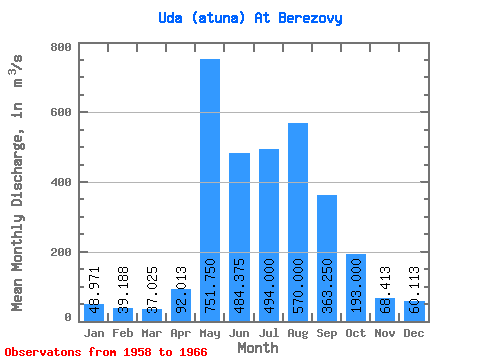
| Statistic | Jan | Feb | Mar | Apr | May | Jun | Jul | Aug | Sep | Oct | Nov | Dec | Annual |
|---|---|---|---|---|---|---|---|---|---|---|---|---|---|
| Mean | 48.97 | 39.19 | 37.02 | 92.01 | 751.75 | 484.38 | 494.00 | 570.00 | 363.25 | 193.00 | 68.41 | 60.11 | 271.42 |
| Standard Deviation | 8.24 | 4.77 | 5.79 | 80.91 | 175.77 | 99.61 | 159.13 | 225.88 | 112.39 | 41.21 | 10.38 | 7.43 | 44.20 |
| Min | 39.20 | 31.00 | 31.30 | 42.90 | 597.00 | 333.00 | 320.00 | 383.00 | 261.00 | 137.00 | 48.30 | 47.30 | 202.25 |
| Max | 60.10 | 46.30 | 47.00 | 288.00 | 1130.00 | 599.00 | 698.00 | 1040.00 | 621.00 | 277.00 | 77.90 | 68.60 | 324.23 |
| Coefficient of Variation | 0.17 | 0.12 | 0.16 | 0.88 | 0.23 | 0.21 | 0.32 | 0.40 | 0.31 | 0.21 | 0.15 | 0.12 | 0.16 |
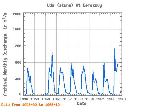
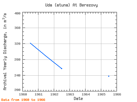
| Year | Jan | Feb | Mar | Apr | May | Jun | Jul | Aug | Sep | Oct | Nov | Dec | Annual | 1958 | 39.80 | 34.00 | 56.80 | 665.00 | 585.00 | 321.00 | 499.00 | 277.00 | 180.00 | 60.00 | 50.80 | 1960 | 40.30 | 31.00 | 31.30 | 64.10 | 674.00 | 499.00 | 444.00 | 1040.00 | 621.00 | 277.00 | 76.90 | 58.90 | 321.46 | 1961 | 50.60 | 46.30 | 47.00 | 288.00 | 680.00 | 530.00 | 579.00 | 536.00 | 377.00 | 190.00 | 72.20 | 68.60 | 288.73 | 1962 | 57.10 | 43.00 | 40.60 | 97.80 | 781.00 | 443.00 | 671.00 | 383.00 | 261.00 | 181.00 | 63.70 | 64.50 | 257.23 | 1963 | 52.30 | 42.30 | 42.80 | 71.50 | 597.00 | 532.00 | 698.00 | 557.00 | 318.00 | 165.00 | 77.90 | 65.70 | 268.29 | 1964 | 60.10 | 38.20 | 32.10 | 49.00 | 622.00 | 333.00 | 320.00 | 404.00 | 336.00 | 137.00 | 48.30 | 47.30 | 202.25 | 1965 | 39.20 | 35.70 | 36.00 | 66.00 | 865.00 | 354.00 | 333.00 | 387.00 | 381.00 | 217.00 | 76.90 | 62.50 | 237.78 | 1966 | 43.20 | 37.20 | 32.40 | 42.90 | 1130.00 | 599.00 | 586.00 | 754.00 | 335.00 | 197.00 | 71.40 | 62.60 | 324.23 |
|---|
 Return to R-Arctic Net Home Page