|
|
|||||||||||||||||
| Point ID: 8229 | Downloads | Plots | Site Data | Code: 8275 |
|
|
|||||||||||||||||
| Download | |
|---|---|
| Site Descriptor Information | Site Time Series Data |
| Link to all available data | |
|
|
| View: | Statistics | Time Series |
| Units: | mm |
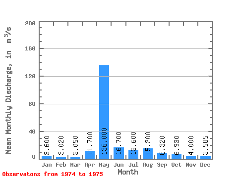
| Statistic | Jan | Feb | Mar | Apr | May | Jun | Jul | Aug | Sep | Oct | Nov | Dec | Annual |
|---|---|---|---|---|---|---|---|---|---|---|---|---|---|
| Mean | 3.60 | 3.02 | 3.05 | 11.70 | 136.00 | 16.70 | 13.60 | 15.20 | 8.32 | 6.93 | 4.00 | 3.58 | 18.68 |
| Standard Deviation | 1.40 | 0.06 | 0.77 | ||||||||||
| Min | 3.60 | 3.02 | 3.05 | 11.70 | 136.00 | 16.70 | 13.60 | 15.20 | 8.32 | 5.94 | 3.96 | 3.04 | 18.68 |
| Max | 3.60 | 3.02 | 3.05 | 11.70 | 136.00 | 16.70 | 13.60 | 15.20 | 8.32 | 7.92 | 4.04 | 4.13 | 18.68 |
| Coefficient of Variation | 0.20 | 0.01 | 0.21 |
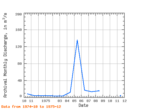
| Year | Jan | Feb | Mar | Apr | May | Jun | Jul | Aug | Sep | Oct | Nov | Dec | Annual | 1974 | 7.92 | 4.04 | 4.13 | 1975 | 3.60 | 3.02 | 3.05 | 11.70 | 136.00 | 16.70 | 13.60 | 15.20 | 8.32 | 5.94 | 3.96 | 3.04 | 18.68 |
|---|
 Return to R-Arctic Net Home Page