|
|
|||||||||||||||||
| Point ID: 8226 | Downloads | Plots | Site Data | Code: 8271 |
|
|
|||||||||||||||||
| Download | |
|---|---|
| Site Descriptor Information | Site Time Series Data |
| Link to all available data | |
|
|
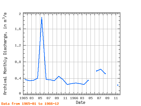
| View: | Statistics | Time Series |
| Units: | mm |
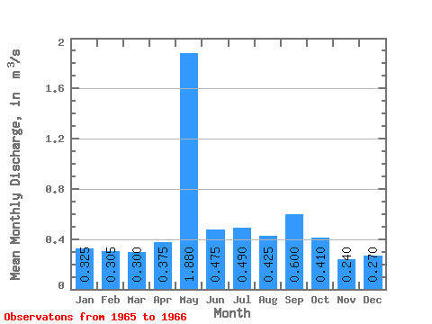
| Statistic | Jan | Feb | Mar | Apr | May | Jun | Jul | Aug | Sep | Oct | Nov | Dec | Annual |
|---|---|---|---|---|---|---|---|---|---|---|---|---|---|
| Mean | 0.33 | 0.30 | 0.30 | 0.38 | 1.88 | 0.47 | 0.49 | 0.42 | 0.60 | 0.41 | 0.24 | 0.27 | 0.48 |
| Standard Deviation | 0.06 | 0.05 | 0.07 | 0.04 | 0.15 | 0.18 | 0.12 | 0.21 | 0.06 | 0.01 | 0.00 | ||
| Min | 0.28 | 0.27 | 0.25 | 0.35 | 1.88 | 0.37 | 0.36 | 0.34 | 0.45 | 0.37 | 0.23 | 0.27 | 0.48 |
| Max | 0.37 | 0.34 | 0.35 | 0.40 | 1.88 | 0.58 | 0.62 | 0.51 | 0.75 | 0.45 | 0.25 | 0.27 | 0.48 |
| Coefficient of Variation | 0.20 | 0.16 | 0.24 | 0.09 | 0.31 | 0.38 | 0.28 | 0.35 | 0.14 | 0.06 | 0.00 |
| Year | Jan | Feb | Mar | Apr | May | Jun | Jul | Aug | Sep | Oct | Nov | Dec | Annual | 1965 | 0.37 | 0.34 | 0.35 | 0.40 | 1.88 | 0.37 | 0.36 | 0.34 | 0.45 | 0.37 | 0.25 | 0.27 | 0.48 | 1966 | 0.28 | 0.27 | 0.25 | 0.35 | 0.58 | 0.62 | 0.51 | 0.75 | 0.45 | 0.23 | 0.27 |
|---|
 Return to R-Arctic Net Home Page