|
|
|||||||||||||||||
| Point ID: 8208 | Downloads | Plots | Site Data | Code: 8218 |
|
|
|||||||||||||||||
| Download | |
|---|---|
| Site Descriptor Information | Site Time Series Data |
| Link to all available data | |
|
|
| View: | Statistics | Time Series |
| Units: | mm |
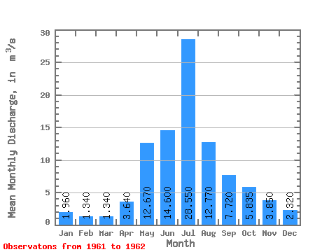
| Statistic | Jan | Feb | Mar | Apr | May | Jun | Jul | Aug | Sep | Oct | Nov | Dec | Annual |
|---|---|---|---|---|---|---|---|---|---|---|---|---|---|
| Mean | 1.96 | 1.34 | 1.34 | 3.64 | 12.67 | 14.60 | 28.55 | 12.77 | 7.72 | 5.83 | 3.85 | 2.32 | 8.32 |
| Standard Deviation | 0.26 | 5.98 | 1.41 | 7.14 | 6.83 | 2.55 | 0.15 | 0.37 | 0.21 | ||||
| Min | 1.96 | 1.34 | 1.34 | 3.46 | 8.44 | 13.60 | 23.50 | 7.94 | 5.92 | 5.73 | 3.59 | 2.17 | 8.32 |
| Max | 1.96 | 1.34 | 1.34 | 3.82 | 16.90 | 15.60 | 33.60 | 17.60 | 9.52 | 5.94 | 4.11 | 2.47 | 8.32 |
| Coefficient of Variation | 0.07 | 0.47 | 0.10 | 0.25 | 0.54 | 0.33 | 0.03 | 0.10 | 0.09 |
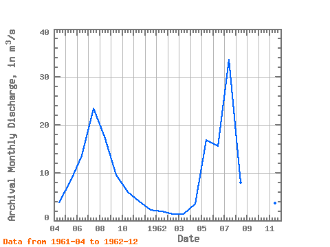
| Year | Jan | Feb | Mar | Apr | May | Jun | Jul | Aug | Sep | Oct | Nov | Dec | Annual | 1961 | 3.82 | 8.44 | 13.60 | 23.50 | 17.60 | 9.52 | 5.94 | 4.11 | 2.17 | 1962 | 1.96 | 1.34 | 1.34 | 3.46 | 16.90 | 15.60 | 33.60 | 7.94 | 5.92 | 5.73 | 3.59 | 2.47 | 8.32 |
|---|
 Return to R-Arctic Net Home Page