|
|
|||||||||||||||||
| Point ID: 8198 | Downloads | Plots | Site Data | Code: 8193 |
|
|
|||||||||||||||||
| Download | |
|---|---|
| Site Descriptor Information | Site Time Series Data |
| Link to all available data | |
| View: | Time Series | All |
| Units: | m3/s |
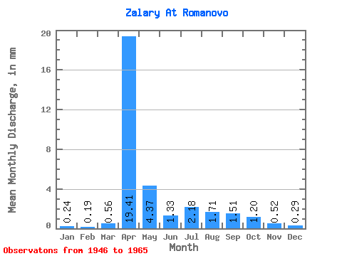
| Statistic | Jan | Feb | Mar | Apr | May | Jun | Jul | Aug | Sep | Oct | Nov | Dec | Annual |
|---|---|---|---|---|---|---|---|---|---|---|---|---|---|
| Mean | 0.24 | 0.19 | 0.56 | 19.41 | 4.37 | 1.33 | 2.18 | 1.71 | 1.52 | 1.21 | 0.52 | 0.29 | 33.57 |
| Standard Deviation | 0.19 | 0.17 | 1.03 | 10.29 | 4.95 | 0.76 | 1.68 | 1.22 | 1.22 | 0.82 | 0.35 | 0.23 | 14.81 |
| Min | 0.00 | 0.00 | 0.00 | 2.19 | 0.68 | 0.59 | 0.47 | 0.37 | 0.36 | 0.37 | 0.16 | 0.03 | 9.90 |
| Max | 0.74 | 0.58 | 4.49 | 42.77 | 18.11 | 3.33 | 7.01 | 4.66 | 4.47 | 3.04 | 1.31 | 0.94 | 66.19 |
| Coefficient of Variation | 0.79 | 0.90 | 1.84 | 0.53 | 1.13 | 0.57 | 0.77 | 0.71 | 0.81 | 0.68 | 0.68 | 0.81 | 0.44 |
 Return to R-Arctic Net Home Page