|
|
|||||||||||||||||
| Point ID: 8196 | Downloads | Plots | Site Data | Code: 8191 |
|
|
|||||||||||||||||
| Download | |
|---|---|
| Site Descriptor Information | Site Time Series Data |
| Link to all available data | |
| View: | Time Series | All |
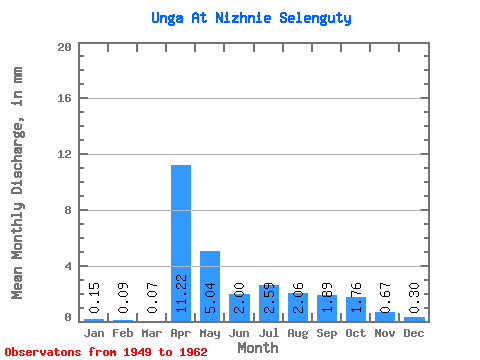
| Units: | m3/s |
| Statistic | Jan | Feb | Mar | Apr | May | Jun | Jul | Aug | Sep | Oct | Nov | Dec | Annual |
|---|---|---|---|---|---|---|---|---|---|---|---|---|---|
| Mean | 0.15 | 0.09 | 0.07 | 11.22 | 5.04 | 2.00 | 2.59 | 2.06 | 1.89 | 1.76 | 0.67 | 0.30 | 27.79 |
| Standard Deviation | 0.17 | 0.12 | 0.10 | 6.17 | 5.43 | 0.67 | 1.29 | 0.68 | 0.69 | 0.58 | 0.29 | 0.22 | 10.99 |
| Min | 0.00 | 0.00 | 0.00 | 4.17 | 1.68 | 1.12 | 0.87 | 1.09 | 1.04 | 1.12 | 0.37 | 0.03 | 13.35 |
| Max | 0.49 | 0.34 | 0.31 | 21.62 | 21.74 | 3.43 | 5.11 | 3.04 | 3.53 | 2.80 | 1.17 | 0.65 | 53.25 |
| Coefficient of Variation | 1.12 | 1.36 | 1.47 | 0.55 | 1.08 | 0.34 | 0.50 | 0.33 | 0.37 | 0.33 | 0.44 | 0.74 | 0.40 |
 Return to R-Arctic Net Home Page