|
|
|||||||||||||||||
| Point ID: 8186 | Downloads | Plots | Site Data | Code: 8163 |
|
|
|||||||||||||||||
| Download | |
|---|---|
| Site Descriptor Information | Site Time Series Data |
| Link to all available data | |
|
|
| View: | Statistics | Time Series |
| Units: | mm |
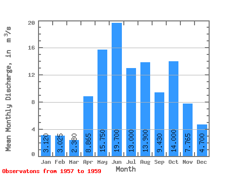
| Statistic | Jan | Feb | Mar | Apr | May | Jun | Jul | Aug | Sep | Oct | Nov | Dec | Annual |
|---|---|---|---|---|---|---|---|---|---|---|---|---|---|
| Mean | 3.12 | 3.02 | 2.38 | 8.87 | 15.75 | 19.70 | 13.00 | 13.90 | 9.43 | 14.00 | 7.76 | 4.70 | 9.29 |
| Standard Deviation | 1.29 | 0.97 | 0.58 | 1.75 | 6.43 | 9.05 | 5.14 | 2.65 | |||||
| Min | 2.21 | 2.34 | 1.97 | 7.63 | 11.20 | 19.70 | 13.00 | 13.90 | 9.43 | 7.60 | 4.13 | 2.83 | 9.29 |
| Max | 4.03 | 3.71 | 2.79 | 10.10 | 20.30 | 19.70 | 13.00 | 13.90 | 9.43 | 20.40 | 11.40 | 6.57 | 9.29 |
| Coefficient of Variation | 0.41 | 0.32 | 0.24 | 0.20 | 0.41 | 0.65 | 0.66 | 0.56 |
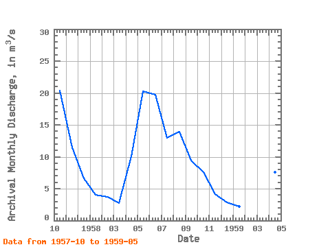
| Year | Jan | Feb | Mar | Apr | May | Jun | Jul | Aug | Sep | Oct | Nov | Dec | Annual | 1957 | 20.40 | 11.40 | 6.57 | 1958 | 4.03 | 3.71 | 2.79 | 10.10 | 20.30 | 19.70 | 13.00 | 13.90 | 9.43 | 7.60 | 4.13 | 2.83 | 9.29 | 1959 | 2.21 | 2.34 | 1.97 | 7.63 | 11.20 |
|---|
 Return to R-Arctic Net Home Page