|
|
|||||||||||||||||
| Point ID: 8184 | Downloads | Plots | Site Data | Code: 8159 |
|
|
|||||||||||||||||
| Download | |
|---|---|
| Site Descriptor Information | Site Time Series Data |
| Link to all available data | |
|
|
| View: | Statistics | Time Series |
| Units: | mm |
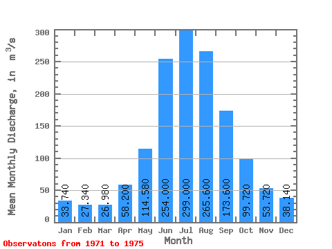
| Statistic | Jan | Feb | Mar | Apr | May | Jun | Jul | Aug | Sep | Oct | Nov | Dec | Annual |
|---|---|---|---|---|---|---|---|---|---|---|---|---|---|
| Mean | 33.74 | 27.34 | 26.98 | 58.20 | 114.58 | 254.00 | 299.00 | 265.60 | 173.60 | 99.72 | 53.72 | 38.14 | 120.39 |
| Standard Deviation | 8.70 | 4.80 | 2.25 | 8.72 | 36.00 | 77.86 | 98.67 | 62.43 | 50.39 | 20.65 | 9.51 | 11.12 | 20.80 |
| Min | 24.90 | 22.20 | 24.10 | 49.40 | 63.00 | 170.00 | 231.00 | 192.00 | 118.00 | 72.00 | 38.10 | 24.30 | 88.00 |
| Max | 45.30 | 34.00 | 30.30 | 70.60 | 154.00 | 341.00 | 459.00 | 323.00 | 252.00 | 125.00 | 60.80 | 48.80 | 143.54 |
| Coefficient of Variation | 0.26 | 0.18 | 0.08 | 0.15 | 0.31 | 0.31 | 0.33 | 0.23 | 0.29 | 0.21 | 0.18 | 0.29 | 0.17 |
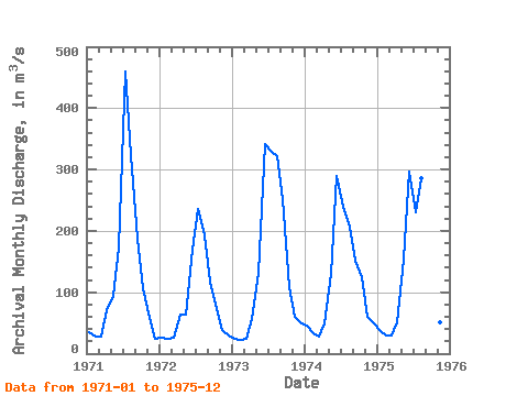
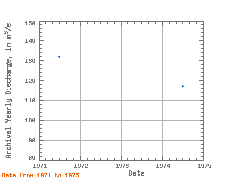
| Year | Jan | Feb | Mar | Apr | May | Jun | Jul | Aug | Sep | Oct | Nov | Dec | Annual | 1971 | 34.50 | 27.10 | 27.20 | 70.60 | 93.90 | 173.00 | 459.00 | 323.00 | 188.00 | 106.00 | 57.90 | 24.30 | 132.04 | 1972 | 25.50 | 23.50 | 26.10 | 63.40 | 63.00 | 170.00 | 235.00 | 192.00 | 118.00 | 72.00 | 38.10 | 29.40 | 88.00 | 1973 | 24.90 | 22.20 | 24.10 | 55.70 | 132.00 | 341.00 | 331.00 | 321.00 | 252.00 | 109.00 | 60.80 | 48.80 | 143.54 | 1974 | 45.30 | 34.00 | 27.20 | 49.40 | 130.00 | 290.00 | 239.00 | 207.00 | 152.00 | 125.00 | 60.40 | 48.70 | 117.33 | 1975 | 38.50 | 29.90 | 30.30 | 51.90 | 154.00 | 296.00 | 231.00 | 285.00 | 158.00 | 86.60 | 51.40 | 39.50 | 121.01 |
|---|
 Return to R-Arctic Net Home Page