|
|
|||||||||||||||||
| Point ID: 8178 | Downloads | Plots | Site Data | Code: 8150 |
|
|
|||||||||||||||||
| Download | |
|---|---|
| Site Descriptor Information | Site Time Series Data |
| Link to all available data | |
| View: | Time Series | All |
| Units: | m3/s |
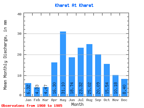
| Statistic | Jan | Feb | Mar | Apr | May | Jun | Jul | Aug | Sep | Oct | Nov | Dec | Annual |
|---|---|---|---|---|---|---|---|---|---|---|---|---|---|
| Mean | 6.32 | 4.37 | 4.47 | 16.30 | 31.09 | 18.73 | 23.32 | 25.01 | 20.09 | 15.54 | 10.18 | 8.39 | 183.38 |
| Standard Deviation | 2.29 | 2.29 | 3.06 | 7.09 | 14.05 | 8.41 | 10.67 | 14.86 | 8.55 | 4.41 | 2.77 | 2.57 | 44.78 |
| Min | 2.70 | 0.85 | 0.01 | 6.57 | 12.46 | 10.08 | 11.72 | 10.88 | 10.71 | 9.11 | 5.76 | 4.74 | 119.99 |
| Max | 11.44 | 9.74 | 13.20 | 29.97 | 61.09 | 47.88 | 49.00 | 82.67 | 46.98 | 23.52 | 15.21 | 13.86 | 265.28 |
| Coefficient of Variation | 0.36 | 0.52 | 0.68 | 0.43 | 0.45 | 0.45 | 0.46 | 0.59 | 0.43 | 0.28 | 0.27 | 0.31 | 0.24 |
 Return to R-Arctic Net Home Page