|
|
|||||||||||||||||
| Point ID: 8177 | Downloads | Plots | Site Data | Code: 8149 |
|
|
|||||||||||||||||
| Download | |
|---|---|
| Site Descriptor Information | Site Time Series Data |
| Link to all available data | |
|
|
| View: | Statistics | Time Series |
| Units: | mm |
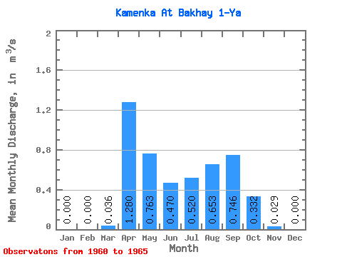
| Statistic | Jan | Feb | Mar | Apr | May | Jun | Jul | Aug | Sep | Oct | Nov | Dec | Annual |
|---|---|---|---|---|---|---|---|---|---|---|---|---|---|
| Mean | 0.00 | 0.00 | 0.04 | 1.28 | 0.76 | 0.47 | 0.52 | 0.65 | 0.75 | 0.33 | 0.03 | 0.00 | 0.41 |
| Standard Deviation | 0.00 | 0.00 | 0.08 | 0.28 | 0.57 | 0.31 | 0.17 | 0.49 | 1.05 | 0.25 | 0.04 | 0.00 | 0.23 |
| Min | 0.00 | 0.00 | 0.00 | 0.92 | 0.39 | 0.18 | 0.35 | 0.09 | 0.10 | 0.09 | 0.00 | 0.00 | 0.24 |
| Max | 0.00 | 0.00 | 0.18 | 1.54 | 1.59 | 0.95 | 0.78 | 1.31 | 2.61 | 0.74 | 0.12 | 0.00 | 0.75 |
| Coefficient of Variation | 2.24 | 0.22 | 0.74 | 0.67 | 0.33 | 0.75 | 1.41 | 0.74 | 1.55 | 0.55 |
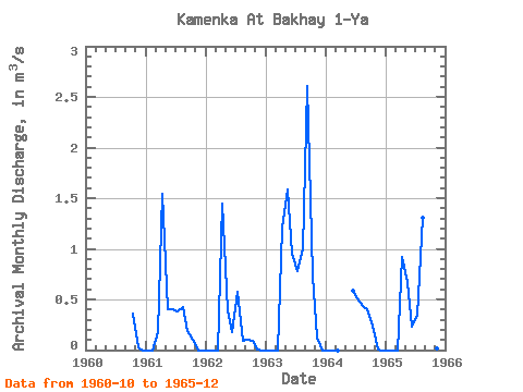
| Year | Jan | Feb | Mar | Apr | May | Jun | Jul | Aug | Sep | Oct | Nov | Dec | Annual | 1960 | 0.36 | 0.03 | 0.00 | 1961 | 0.00 | 0.00 | 0.18 | 1.54 | 0.40 | 0.40 | 0.38 | 0.42 | 0.19 | 0.10 | 0.00 | 0.00 | 0.30 | 1962 | 0.00 | 0.00 | 0.00 | 1.45 | 0.39 | 0.18 | 0.58 | 0.09 | 0.10 | 0.09 | 0.01 | 0.00 | 0.24 | 1963 | 0.00 | 0.00 | 0.00 | 1.21 | 1.59 | 0.95 | 0.78 | 1.00 | 2.61 | 0.74 | 0.12 | 0.00 | 0.75 | 1964 | 0.00 | 0.00 | 0.00 | 0.59 | 0.51 | 0.44 | 0.40 | 0.24 | 0.01 | 0.00 | 1965 | 0.00 | 0.00 | 0.00 | 0.92 | 0.67 | 0.23 | 0.35 | 1.31 | 0.43 | 0.46 | 0.01 | 0.00 | 0.36 |
|---|
 Return to R-Arctic Net Home Page