|
|
|||||||||||||||||
| Point ID: 8166 | Downloads | Plots | Site Data | Code: 8124 |
|
|
|||||||||||||||||
| Download | |
|---|---|
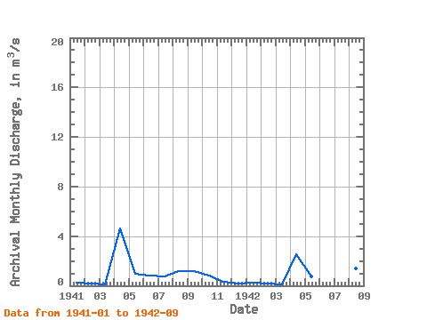
| Site Descriptor Information | Site Time Series Data |
| Link to all available data | |
|
|
| View: | Statistics | Time Series |
| Units: | mm |
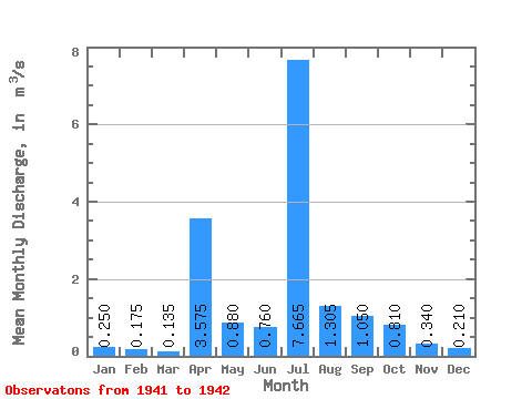
| Statistic | Jan | Feb | Mar | Apr | May | Jun | Jul | Aug | Sep | Oct | Nov | Dec | Annual |
|---|---|---|---|---|---|---|---|---|---|---|---|---|---|
| Mean | 0.25 | 0.17 | 0.14 | 3.58 | 0.88 | 0.76 | 7.67 | 1.30 | 1.05 | 0.81 | 0.34 | 0.21 | 0.96 |
| Standard Deviation | 0.00 | 0.02 | 0.01 | 1.49 | 0.17 | 0.10 | 9.81 | 0.15 | 0.20 | ||||
| Min | 0.25 | 0.16 | 0.13 | 2.52 | 0.76 | 0.69 | 0.73 | 1.20 | 0.91 | 0.81 | 0.34 | 0.21 | 0.96 |
| Max | 0.25 | 0.19 | 0.14 | 4.63 | 1.00 | 0.83 | 14.60 | 1.41 | 1.19 | 0.81 | 0.34 | 0.21 | 0.96 |
| Coefficient of Variation | 0.00 | 0.12 | 0.05 | 0.42 | 0.19 | 0.13 | 1.28 | 0.11 | 0.19 |
| Year | Jan | Feb | Mar | Apr | May | Jun | Jul | Aug | Sep | Oct | Nov | Dec | Annual | 1941 | 0.25 | 0.16 | 0.13 | 4.63 | 1.00 | 0.83 | 0.73 | 1.20 | 1.19 | 0.81 | 0.34 | 0.21 | 0.96 | 1942 | 0.25 | 0.19 | 0.14 | 2.52 | 0.76 | 0.69 | 14.60 | 1.41 | 0.91 |
|---|
 Return to R-Arctic Net Home Page