|
|
|||||||||||||||||
| Point ID: 8158 | Downloads | Plots | Site Data | Code: 8063 |
|
|
|||||||||||||||||
| Download | |
|---|---|
| Site Descriptor Information | Site Time Series Data |
| Link to all available data | |
|
|
| View: | Statistics | Time Series |
| Units: | mm |
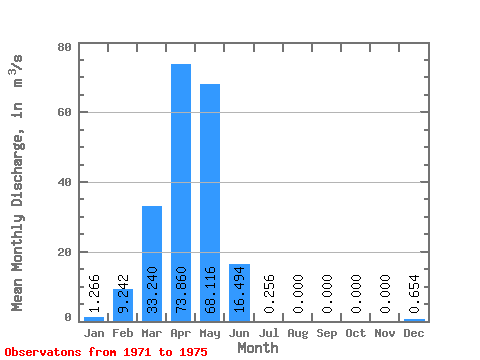
| Statistic | Jan | Feb | Mar | Apr | May | Jun | Jul | Aug | Sep | Oct | Nov | Dec | Annual |
|---|---|---|---|---|---|---|---|---|---|---|---|---|---|
| Mean | 1.27 | 9.24 | 33.24 | 73.86 | 68.12 | 16.49 | 0.26 | 0.00 | 0.00 | 0.00 | 0.00 | 0.65 | 16.93 |
| Standard Deviation | 1.74 | 9.16 | 33.43 | 39.20 | 63.15 | 23.96 | 0.57 | 0.00 | 0.00 | 0.00 | 0.00 | 1.39 | 11.56 |
| Min | 0.00 | 0.00 | 0.00 | 7.40 | 0.23 | 0.00 | 0.00 | 0.00 | 0.00 | 0.00 | 0.00 | 0.00 | 0.65 |
| Max | 3.43 | 18.70 | 86.20 | 109.00 | 133.00 | 55.80 | 1.28 | 0.00 | 0.00 | 0.00 | 0.00 | 3.14 | 30.18 |
| Coefficient of Variation | 1.38 | 0.99 | 1.01 | 0.53 | 0.93 | 1.45 | 2.24 | 2.13 | 0.68 |
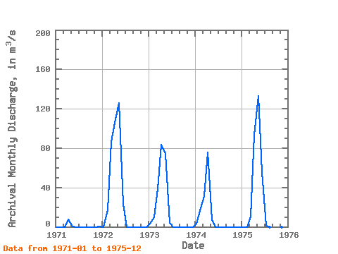
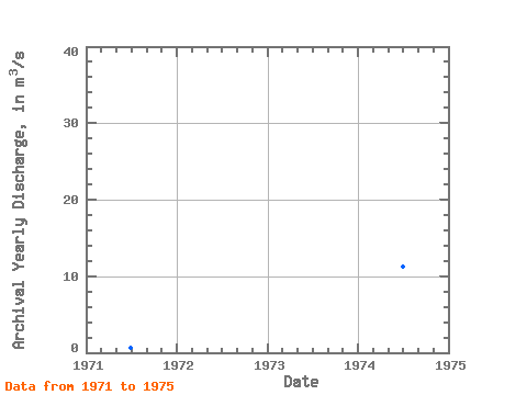
| Year | Jan | Feb | Mar | Apr | May | Jun | Jul | Aug | Sep | Oct | Nov | Dec | Annual | 1971 | 0.00 | 0.00 | 0.00 | 7.40 | 0.23 | 0.00 | 0.00 | 0.00 | 0.00 | 0.00 | 0.00 | 0.13 | 0.65 | 1972 | 0.00 | 17.90 | 86.20 | 109.00 | 126.00 | 23.00 | 0.00 | 0.00 | 0.00 | 0.00 | 0.00 | 0.00 | 30.18 | 1973 | 3.43 | 9.61 | 38.70 | 83.50 | 74.40 | 3.67 | 0.00 | 0.00 | 0.00 | 0.00 | 0.00 | 0.00 | 17.78 | 1974 | 2.90 | 18.70 | 31.00 | 75.60 | 6.95 | 0.00 | 0.00 | 0.00 | 0.00 | 0.00 | 0.00 | 0.00 | 11.26 | 1975 | 0.00 | 0.00 | 10.30 | 93.80 | 133.00 | 55.80 | 1.28 | 0.00 | 0.00 | 0.00 | 0.00 | 3.14 | 24.78 |
|---|
 Return to R-Arctic Net Home Page