|
|
|||||||||||||||||
| Point ID: 8157 | Downloads | Plots | Site Data | Code: 8062 |
|
|
|||||||||||||||||
| Download | |
|---|---|
| Site Descriptor Information | Site Time Series Data |
| Link to all available data | |
|
|
| View: | Statistics | Time Series |
| Units: | mm |
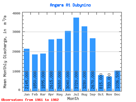
| Statistic | Jan | Feb | Mar | Apr | May | Jun | Jul | Aug | Sep | Oct | Nov | Dec | Annual |
|---|---|---|---|---|---|---|---|---|---|---|---|---|---|
| Mean | 2145.00 | 1850.00 | 1895.00 | 2615.00 | 2650.00 | 3040.00 | 3720.00 | 3280.00 | 2670.00 | 815.00 | 733.00 | 1036.50 | 2204.12 |
| Standard Deviation | 176.78 | 240.42 | 233.34 | 997.02 | 763.67 | 749.53 | 890.96 | 650.54 | 0.00 | 192.33 | 45.26 | 132.23 | 383.07 |
| Min | 2020.00 | 1680.00 | 1730.00 | 1910.00 | 2110.00 | 2510.00 | 3090.00 | 2820.00 | 2670.00 | 679.00 | 701.00 | 943.00 | 1933.25 |
| Max | 2270.00 | 2020.00 | 2060.00 | 3320.00 | 3190.00 | 3570.00 | 4350.00 | 3740.00 | 2670.00 | 951.00 | 765.00 | 1130.00 | 2475.00 |
| Coefficient of Variation | 0.08 | 0.13 | 0.12 | 0.38 | 0.29 | 0.25 | 0.24 | 0.20 | 0.00 | 0.24 | 0.06 | 0.13 | 0.17 |
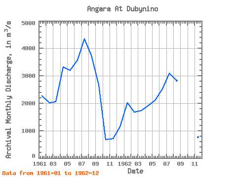
| Year | Jan | Feb | Mar | Apr | May | Jun | Jul | Aug | Sep | Oct | Nov | Dec | Annual | 1961 | 2270.00 | 2020.00 | 2060.00 | 3320.00 | 3190.00 | 3570.00 | 4350.00 | 3740.00 | 2670.00 | 679.00 | 701.00 | 1130.00 | 2475.00 | 1962 | 2020.00 | 1680.00 | 1730.00 | 1910.00 | 2110.00 | 2510.00 | 3090.00 | 2820.00 | 2670.00 | 951.00 | 765.00 | 943.00 | 1933.25 |
|---|
 Return to R-Arctic Net Home Page