|
|
|||||||||||||||||
| Point ID: 8156 | Downloads | Plots | Site Data | Code: 8061 |
|
|
|||||||||||||||||
| Download | |
|---|---|
| Site Descriptor Information | Site Time Series Data |
| Link to all available data | |
|
|
| View: | Statistics | Time Series |
| Units: | mm |
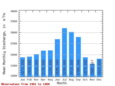
| Statistic | Jan | Feb | Mar | Apr | May | Jun | Jul | Aug | Sep | Oct | Nov | Dec | Annual |
|---|---|---|---|---|---|---|---|---|---|---|---|---|---|
| Mean | 1873.33 | 1903.33 | 2015.00 | 2178.33 | 2193.33 | 2695.00 | 3190.00 | 3013.33 | 2785.00 | 1873.33 | 1582.67 | 1813.83 | 2259.71 |
| Standard Deviation | 443.25 | 265.98 | 168.85 | 570.14 | 526.45 | 574.27 | 633.21 | 400.48 | 148.69 | 841.65 | 694.68 | 614.80 | 183.26 |
| Min | 1080.00 | 1520.00 | 1730.00 | 1820.00 | 1790.00 | 2030.00 | 2730.00 | 2740.00 | 2670.00 | 679.00 | 701.00 | 943.00 | 1933.25 |
| Max | 2270.00 | 2270.00 | 2230.00 | 3320.00 | 3190.00 | 3570.00 | 4350.00 | 3740.00 | 3070.00 | 2570.00 | 2330.00 | 2360.00 | 2475.00 |
| Coefficient of Variation | 0.24 | 0.14 | 0.08 | 0.26 | 0.24 | 0.21 | 0.20 | 0.13 | 0.05 | 0.45 | 0.44 | 0.34 | 0.08 |
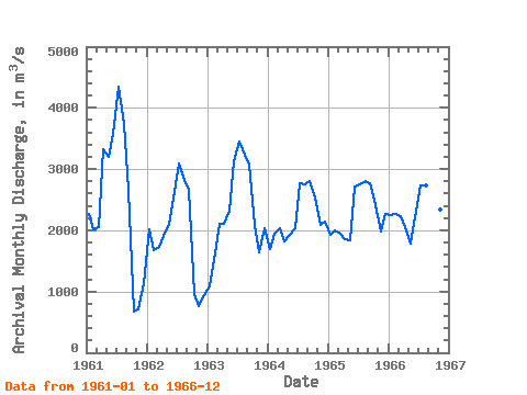
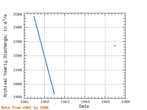
| Year | Jan | Feb | Mar | Apr | May | Jun | Jul | Aug | Sep | Oct | Nov | Dec | Annual | 1961 | 2270.00 | 2020.00 | 2060.00 | 3320.00 | 3190.00 | 3570.00 | 4350.00 | 3740.00 | 2670.00 | 679.00 | 701.00 | 1130.00 | 2475.00 | 1962 | 2020.00 | 1680.00 | 1730.00 | 1910.00 | 2110.00 | 2510.00 | 3090.00 | 2820.00 | 2670.00 | 951.00 | 765.00 | 943.00 | 1933.25 | 1963 | 1080.00 | 1520.00 | 2100.00 | 2100.00 | 2320.00 | 3120.00 | 3450.00 | 3230.00 | 3070.00 | 2090.00 | 1640.00 | 2040.00 | 2313.33 | 1964 | 1700.00 | 1940.00 | 2030.00 | 1820.00 | 1920.00 | 2030.00 | 2770.00 | 2750.00 | 2800.00 | 2540.00 | 2080.00 | 2140.00 | 2210.00 | 1965 | 1920.00 | 1990.00 | 1940.00 | 1860.00 | 1830.00 | 2720.00 | 2750.00 | 2800.00 | 2760.00 | 2410.00 | 1980.00 | 2270.00 | 2269.17 | 1966 | 2250.00 | 2270.00 | 2230.00 | 2060.00 | 1790.00 | 2220.00 | 2730.00 | 2740.00 | 2740.00 | 2570.00 | 2330.00 | 2360.00 | 2357.50 |
|---|
 Return to R-Arctic Net Home Page