|
|
|||||||||||||||||
| Point ID: 8153 | Downloads | Plots | Site Data | Code: 8037 |
|
|
|||||||||||||||||
| Download | |
|---|---|
| Site Descriptor Information | Site Time Series Data |
| Link to all available data | |
|
|
| View: | Statistics | Time Series |
| Units: | mm |
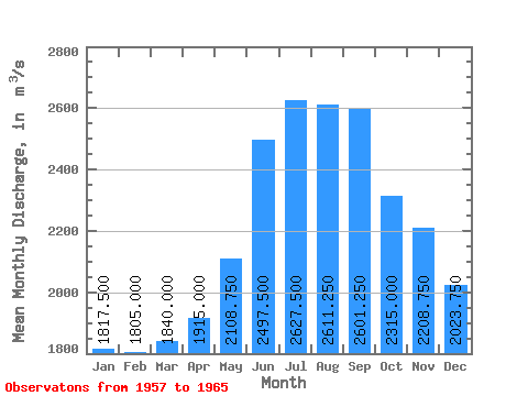
| Statistic | Jan | Feb | Mar | Apr | May | Jun | Jul | Aug | Sep | Oct | Nov | Dec | Annual |
|---|---|---|---|---|---|---|---|---|---|---|---|---|---|
| Mean | 1817.50 | 1805.00 | 1840.00 | 1915.00 | 2108.75 | 2497.50 | 2627.50 | 2611.25 | 2601.25 | 2315.00 | 2208.75 | 2023.75 | 2197.60 |
| Standard Deviation | 383.92 | 471.74 | 529.23 | 560.41 | 486.78 | 348.62 | 279.94 | 364.08 | 384.09 | 426.21 | 395.38 | 347.27 | 257.26 |
| Min | 1300.00 | 1230.00 | 1240.00 | 1350.00 | 1530.00 | 2130.00 | 2220.00 | 2200.00 | 2230.00 | 1710.00 | 1540.00 | 1400.00 | 1745.00 |
| Max | 2480.00 | 2450.00 | 2800.00 | 3010.00 | 2980.00 | 3060.00 | 3210.00 | 3230.00 | 3390.00 | 2990.00 | 2910.00 | 2510.00 | 2539.17 |
| Coefficient of Variation | 0.21 | 0.26 | 0.29 | 0.29 | 0.23 | 0.14 | 0.11 | 0.14 | 0.15 | 0.18 | 0.18 | 0.17 | 0.12 |
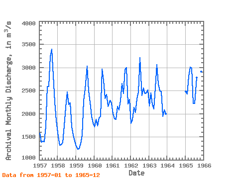
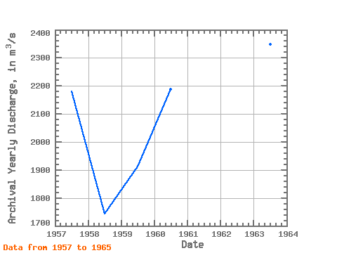
| Year | Jan | Feb | Mar | Apr | May | Jun | Jul | Aug | Sep | Oct | Nov | Dec | Annual | 1957 | 1580.00 | 1380.00 | 1400.00 | 1390.00 | 1720.00 | 2590.00 | 2590.00 | 3230.00 | 3390.00 | 2820.00 | 2250.00 | 1840.00 | 2181.67 | 1958 | 1500.00 | 1320.00 | 1330.00 | 1370.00 | 1740.00 | 2130.00 | 2470.00 | 2200.00 | 2230.00 | 1710.00 | 1540.00 | 1400.00 | 1745.00 | 1959 | 1300.00 | 1230.00 | 1240.00 | 1350.00 | 1530.00 | 2270.00 | 2530.00 | 3030.00 | 2490.00 | 2240.00 | 1940.00 | 1790.00 | 1911.67 | 1960 | 1720.00 | 1880.00 | 1740.00 | 1910.00 | 1940.00 | 2960.00 | 2710.00 | 2330.00 | 2410.00 | 2160.00 | 2290.00 | 2220.00 | 2189.17 | 1961 | 2000.00 | 1890.00 | 1880.00 | 2160.00 | 2080.00 | 2280.00 | 2650.00 | 2440.00 | 2950.00 | 2990.00 | 2210.00 | 2310.00 | 2320.00 | 1962 | 1790.00 | 1870.00 | 2130.00 | 2030.00 | 2320.00 | 2470.00 | 3210.00 | 2390.00 | 2550.00 | 2440.00 | 2450.00 | 2510.00 | 2346.67 | 1963 | 2170.00 | 2450.00 | 2200.00 | 2100.00 | 2560.00 | 3060.00 | 2640.00 | 2490.00 | 2480.00 | 1940.00 | 2080.00 | 2000.00 | 2347.50 | 1965 | 2480.00 | 2420.00 | 2800.00 | 3010.00 | 2980.00 | 2220.00 | 2220.00 | 2780.00 | 2310.00 | 2220.00 | 2910.00 | 2120.00 | 2539.17 |
|---|
 Return to R-Arctic Net Home Page