|
|
|||||||||||||||||
| Point ID: 8152 | Downloads | Plots | Site Data | Code: 8036 |
|
|
|||||||||||||||||
| Download | |
|---|---|
| Site Descriptor Information | Site Time Series Data |
| Link to all available data | |
|
|
| View: | Statistics | Time Series |
| Units: | mm |
| Statistic | Jan | Feb | Mar | Apr | May | Jun | Jul | Aug | Sep | Oct | Nov | Dec | Annual |
|---|---|---|---|---|---|---|---|---|---|---|---|---|---|
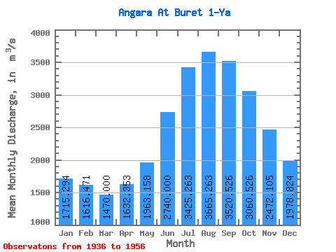
| Mean | 1715.29 | 1616.47 | 1470.00 | 1632.35 | 1963.16 | 2740.00 | 3425.26 | 3665.26 | 3520.53 | 3060.53 | 2472.11 | 1978.82 | 2420.29 |
| Standard Deviation | 289.38 | 264.79 | 232.43 | 267.97 | 225.93 | 458.45 | 590.12 | 467.61 | 514.47 | 457.31 | 381.56 | 355.67 | 277.50 |
| Min | 1260.00 | 1280.00 | 1170.00 | 1270.00 | 1480.00 | 2020.00 | 2810.00 | 3010.00 | 2560.00 | 2230.00 | 1890.00 | 1500.00 | 1955.00 |
| Max | 2390.00 | 2250.00 | 2000.00 | 2350.00 | 2510.00 | 4020.00 | 5200.00 | 4590.00 | 4340.00 | 4030.00 | 3390.00 | 2740.00 | 3021.67 |
| Coefficient of Variation | 0.17 | 0.16 | 0.16 | 0.16 | 0.12 | 0.17 | 0.17 | 0.13 | 0.15 | 0.15 | 0.15 | 0.18 | 0.12 |
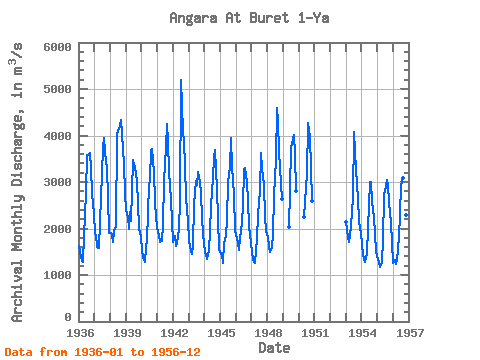
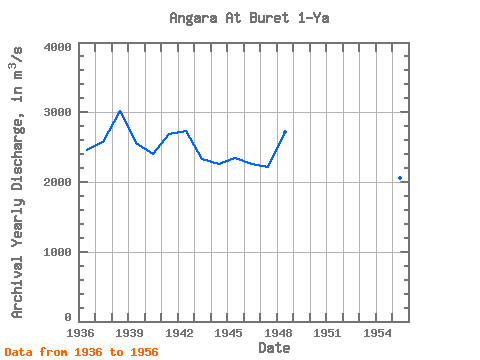
| Year | Jan | Feb | Mar | Apr | May | Jun | Jul | Aug | Sep | Oct | Nov | Dec | Annual | 1936 | 1620.00 | 1500.00 | 1300.00 | 1290.00 | 1840.00 | 2760.00 | 3570.00 | 3590.00 | 3620.00 | 3310.00 | 2740.00 | 2320.00 | 2455.00 | 1937 | 1880.00 | 1850.00 | 1610.00 | 1590.00 | 2160.00 | 2650.00 | 3730.00 | 3950.00 | 3640.00 | 3290.00 | 2700.00 | 1900.00 | 2579.17 | 1938 | 1900.00 | 1870.00 | 1700.00 | 1940.00 | 2030.00 | 4020.00 | 4090.00 | 4210.00 | 4340.00 | 4030.00 | 3390.00 | 2740.00 | 3021.67 | 1939 | 2390.00 | 2250.00 | 2000.00 | 2350.00 | 2170.00 | 3480.00 | 3370.00 | 3330.00 | 3030.00 | 2520.00 | 2020.00 | 1820.00 | 2560.83 | 1940 | 1510.00 | 1380.00 | 1290.00 | 1570.00 | 1750.00 | 2930.00 | 3040.00 | 3680.00 | 3720.00 | 3190.00 | 2600.00 | 2220.00 | 2406.67 | 1941 | 1900.00 | 1860.00 | 1720.00 | 1730.00 | 2100.00 | 3030.00 | 3760.00 | 4240.00 | 3870.00 | 3240.00 | 2620.00 | 2160.00 | 2685.83 | 1942 | 1720.00 | 1830.00 | 1630.00 | 1690.00 | 1990.00 | 2600.00 | 5200.00 | 4100.00 | 3860.00 | 3340.00 | 2650.00 | 2160.00 | 2730.83 | 1943 | 1760.00 | 1610.00 | 1460.00 | 1640.00 | 2510.00 | 3020.00 | 2940.00 | 3210.00 | 3010.00 | 2750.00 | 2240.00 | 1880.00 | 2335.83 | 1944 | 1490.00 | 1420.00 | 1340.00 | 1540.00 | 1930.00 | 2490.00 | 3100.00 | 3510.00 | 3690.00 | 2860.00 | 2220.00 | 1540.00 | 2260.83 | 1945 | 1450.00 | 1440.00 | 1250.00 | 1680.00 | 1840.00 | 2200.00 | 2990.00 | 3330.00 | 3940.00 | 3330.00 | 2720.00 | 1940.00 | 2342.50 | 1946 | 1860.00 | 1690.00 | 1540.00 | 1810.00 | 1910.00 | 2460.00 | 3270.00 | 3300.00 | 3000.00 | 2600.00 | 2050.00 | 1680.00 | 2264.17 | 1947 | 1500.00 | 1330.00 | 1250.00 | 1510.00 | 1780.00 | 2290.00 | 2820.00 | 3630.00 | 3280.00 | 2940.00 | 2250.00 | 1950.00 | 2210.83 | 1948 | 1810.00 | 1600.00 | 1490.00 | 1600.00 | 1890.00 | 2700.00 | 3470.00 | 4590.00 | 4290.00 | 3650.00 | 2950.00 | 2630.00 | 2722.50 | 1949 | 2040.00 | 2830.00 | 3740.00 | 3930.00 | 4010.00 | 3570.00 | 2810.00 | 1950 | 2250.00 | 2890.00 | 3170.00 | 4260.00 | 3970.00 | 3310.00 | 2590.00 | 1953 | 2130.00 | 1810.00 | 1720.00 | 1850.00 | 2060.00 | 2650.00 | 4070.00 | 3650.00 | 2940.00 | 2660.00 | 2140.00 | 1900.00 | 2465.00 | 1954 | 1660.00 | 1440.00 | 1290.00 | 1370.00 | 1480.00 | 2020.00 | 3010.00 | 3010.00 | 2560.00 | 2230.00 | 1890.00 | 1500.00 | 1955.00 | 1955 | 1320.00 | 1280.00 | 1170.00 | 1270.00 | 1760.00 | 2720.00 | 2810.00 | 3040.00 | 2920.00 | 2560.00 | 2110.00 | 1690.00 | 2054.17 | 1956 | 1260.00 | 1320.00 | 1230.00 | 1320.00 | 1810.00 | 2320.00 | 2930.00 | 3080.00 | 3200.00 | 2770.00 | 2280.00 | 1610.00 | 2094.17 |
|---|
 Return to R-Arctic Net Home Page