|
|
|||||||||||||||||
| Point ID: 8150 | Downloads | Plots | Site Data | Code: 8028 |
|
|
|||||||||||||||||
| Download | |
|---|---|
| Site Descriptor Information | Site Time Series Data |
| Link to all available data | |
|
|
| View: | Statistics | Time Series |
| Units: | mm |
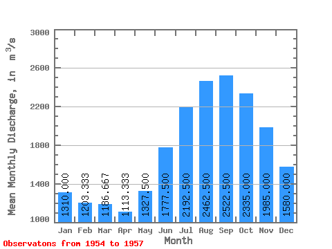
| Statistic | Jan | Feb | Mar | Apr | May | Jun | Jul | Aug | Sep | Oct | Nov | Dec | Annual |
|---|---|---|---|---|---|---|---|---|---|---|---|---|---|
| Mean | 1310.00 | 1203.33 | 1186.67 | 1113.33 | 1327.50 | 1777.50 | 2192.50 | 2462.50 | 2522.50 | 2335.00 | 1985.00 | 1580.00 | 1798.06 |
| Standard Deviation | 141.77 | 85.05 | 102.63 | 68.07 | 62.38 | 213.44 | 82.21 | 98.11 | 247.84 | 261.85 | 202.40 | 149.67 | 59.30 |
| Min | 1200.00 | 1140.00 | 1100.00 | 1060.00 | 1260.00 | 1520.00 | 2120.00 | 2320.00 | 2170.00 | 1970.00 | 1700.00 | 1380.00 | 1747.50 |
| Max | 1470.00 | 1300.00 | 1300.00 | 1190.00 | 1410.00 | 1990.00 | 2310.00 | 2540.00 | 2710.00 | 2530.00 | 2160.00 | 1740.00 | 1863.33 |
| Coefficient of Variation | 0.11 | 0.07 | 0.09 | 0.06 | 0.05 | 0.12 | 0.04 | 0.04 | 0.10 | 0.11 | 0.10 | 0.10 | 0.03 |
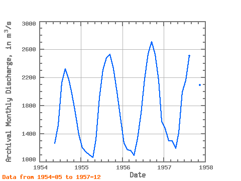
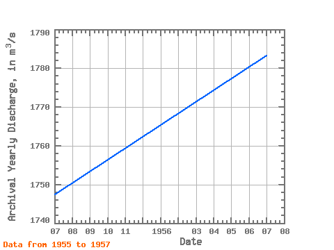
| Year | Jan | Feb | Mar | Apr | May | Jun | Jul | Aug | Sep | Oct | Nov | Dec | Annual | 1954 | 1260.00 | 1520.00 | 2120.00 | 2320.00 | 2170.00 | 1970.00 | 1700.00 | 1380.00 | 1955 | 1200.00 | 1140.00 | 1100.00 | 1060.00 | 1310.00 | 1910.00 | 2310.00 | 2480.00 | 2530.00 | 2320.00 | 1990.00 | 1620.00 | 1747.50 | 1956 | 1260.00 | 1170.00 | 1160.00 | 1090.00 | 1330.00 | 1690.00 | 2180.00 | 2540.00 | 2710.00 | 2530.00 | 2160.00 | 1580.00 | 1783.33 | 1957 | 1470.00 | 1300.00 | 1300.00 | 1190.00 | 1410.00 | 1990.00 | 2160.00 | 2510.00 | 2680.00 | 2520.00 | 2090.00 | 1740.00 | 1863.33 |
|---|
 Return to R-Arctic Net Home Page