|
|
|||||||||||||||||
| Point ID: 8149 | Downloads | Plots | Site Data | Code: 8027 |
|
|
|||||||||||||||||
| Download | |
|---|---|
| Site Descriptor Information | Site Time Series Data |
| Link to all available data | |
|
|
| View: | Statistics | Time Series |
| Units: | mm |
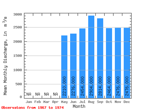
| Statistic | Jan | Feb | Mar | Apr | May | Jun | Jul | Aug | Sep | Oct | Nov | Dec | Annual |
|---|---|---|---|---|---|---|---|---|---|---|---|---|---|
| Mean | 2210.00 | 2276.00 | 2454.00 | 2904.00 | 2814.00 | 2464.00 | 2476.00 | 2476.00 | |||||
| Standard Deviation | 228.80 | 286.93 | 528.19 | 740.83 | 800.99 | 563.23 | 493.69 | 467.58 | |||||
| Min | 1850.00 | 1870.00 | 1960.00 | 1930.00 | 1780.00 | 1740.00 | 1720.00 | 1650.00 | |||||
| Max | 2430.00 | 2580.00 | 3220.00 | 3840.00 | 3940.00 | 3120.00 | 2900.00 | 2800.00 | |||||
| Coefficient of Variation | 0.10 | 0.13 | 0.21 | 0.26 | 0.28 | 0.23 | 0.20 | 0.19 |
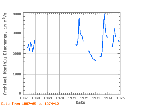
| Year | Jan | Feb | Mar | Apr | May | Jun | Jul | Aug | Sep | Oct | Nov | Dec | Annual | 1967 | 2300.00 | 2450.00 | 2160.00 | 2530.00 | 2400.00 | 2080.00 | 2270.00 | 2620.00 | 1971 | 2430.00 | 2380.00 | 2780.00 | 3840.00 | 3030.00 | 2870.00 | 2900.00 | 2620.00 | 1972 | 2130.00 | 2100.00 | 1960.00 | 1930.00 | 1780.00 | 1740.00 | 1720.00 | 1650.00 | 1973 | 1850.00 | 1870.00 | 2150.00 | 3380.00 | 3940.00 | 3120.00 | 2880.00 | 2800.00 | 1974 | 2340.00 | 2580.00 | 3220.00 | 2840.00 | 2920.00 | 2510.00 | 2610.00 | 2690.00 |
|---|
 Return to R-Arctic Net Home Page