|
|
|||||||||||||||||
| Point ID: 8148 | Downloads | Plots | Site Data | Code: 8023 |
|
|
|||||||||||||||||
| Download | |
|---|---|
| Site Descriptor Information | Site Time Series Data |
| Link to all available data | |
|
|
| View: | Statistics | Time Series |
| Units: | mm |
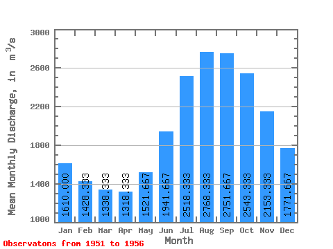
| Statistic | Jan | Feb | Mar | Apr | May | Jun | Jul | Aug | Sep | Oct | Nov | Dec | Annual |
|---|---|---|---|---|---|---|---|---|---|---|---|---|---|
| Mean | 1610.00 | 1428.33 | 1338.33 | 1318.33 | 1521.67 | 1941.67 | 2518.33 | 2768.33 | 2751.67 | 2543.33 | 2153.33 | 1771.67 | 1972.08 |
| Standard Deviation | 323.98 | 239.87 | 231.81 | 255.61 | 287.71 | 344.47 | 416.62 | 422.77 | 451.28 | 447.91 | 371.25 | 330.66 | 308.43 |
| Min | 1250.00 | 1100.00 | 1040.00 | 1010.00 | 1140.00 | 1440.00 | 2080.00 | 2400.00 | 2220.00 | 1970.00 | 1680.00 | 1410.00 | 1634.17 |
| Max | 2080.00 | 1720.00 | 1640.00 | 1620.00 | 1840.00 | 2290.00 | 3090.00 | 3480.00 | 3500.00 | 3240.00 | 2710.00 | 2260.00 | 2374.17 |
| Coefficient of Variation | 0.20 | 0.17 | 0.17 | 0.19 | 0.19 | 0.18 | 0.17 | 0.15 | 0.16 | 0.18 | 0.17 | 0.19 | 0.16 |
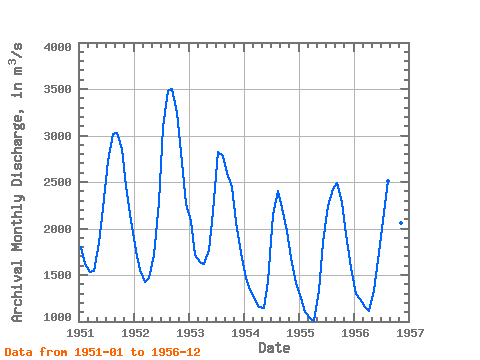
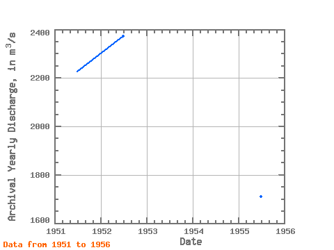
| Year | Jan | Feb | Mar | Apr | May | Jun | Jul | Aug | Sep | Oct | Nov | Dec | Annual | 1951 | 1800.00 | 1620.00 | 1530.00 | 1540.00 | 1840.00 | 2220.00 | 2730.00 | 3020.00 | 3030.00 | 2860.00 | 2460.00 | 2080.00 | 2227.50 | 1952 | 1760.00 | 1550.00 | 1430.00 | 1470.00 | 1710.00 | 2290.00 | 3090.00 | 3480.00 | 3500.00 | 3240.00 | 2710.00 | 2260.00 | 2374.17 | 1953 | 2080.00 | 1720.00 | 1640.00 | 1620.00 | 1770.00 | 2180.00 | 2820.00 | 2780.00 | 2600.00 | 2450.00 | 2070.00 | 1740.00 | 2122.50 | 1954 | 1470.00 | 1340.00 | 1230.00 | 1160.00 | 1140.00 | 1440.00 | 2150.00 | 2400.00 | 2220.00 | 1970.00 | 1680.00 | 1410.00 | 1634.17 | 1955 | 1250.00 | 1100.00 | 1040.00 | 1010.00 | 1330.00 | 1860.00 | 2240.00 | 2420.00 | 2490.00 | 2270.00 | 1940.00 | 1570.00 | 1710.00 | 1956 | 1300.00 | 1240.00 | 1160.00 | 1110.00 | 1340.00 | 1660.00 | 2080.00 | 2510.00 | 2670.00 | 2470.00 | 2060.00 | 1570.00 | 1764.17 |
|---|
 Return to R-Arctic Net Home Page