|
|
|||||||||||||||||
| Point ID: 8139 | Downloads | Plots | Site Data | Code: 7192 |
|
|
|||||||||||||||||
| Download | |
|---|---|
| Site Descriptor Information | Site Time Series Data |
| Link to all available data | |
|
|
| View: | Statistics | Time Series |
| Units: | mm |
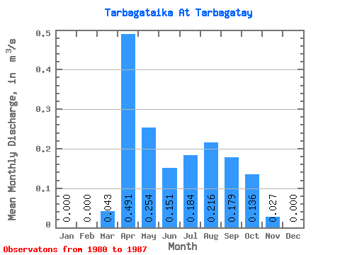
| Statistic | Jan | Feb | Mar | Apr | May | Jun | Jul | Aug | Sep | Oct | Nov | Dec | Annual |
|---|---|---|---|---|---|---|---|---|---|---|---|---|---|
| Mean | 0.00 | 0.00 | 0.04 | 0.49 | 0.25 | 0.15 | 0.18 | 0.22 | 0.18 | 0.14 | 0.03 | 0.00 | 0.14 |
| Standard Deviation | 0.00 | 0.00 | 0.05 | 0.22 | 0.14 | 0.06 | 0.06 | 0.10 | 0.13 | 0.06 | 0.02 | 0.00 | 0.06 |
| Min | 0.00 | 0.00 | 0.00 | 0.23 | 0.13 | 0.06 | 0.11 | 0.12 | 0.08 | 0.08 | 0.00 | 0.00 | 0.09 |
| Max | 0.00 | 0.00 | 0.11 | 0.87 | 0.57 | 0.25 | 0.26 | 0.38 | 0.42 | 0.26 | 0.06 | 0.00 | 0.23 |
| Coefficient of Variation | 1.13 | 0.45 | 0.56 | 0.41 | 0.30 | 0.48 | 0.74 | 0.43 | 0.83 | 0.42 |
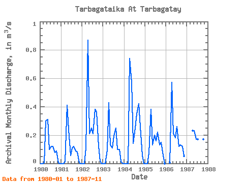
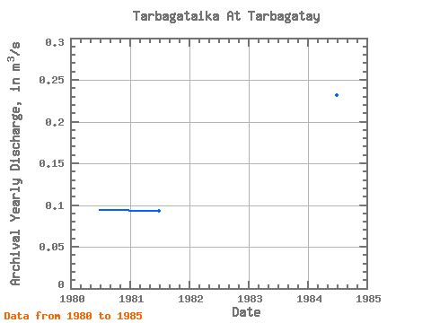
| Year | Jan | Feb | Mar | Apr | May | Jun | Jul | Aug | Sep | Oct | Nov | Dec | Annual | 1980 | 0.00 | 0.00 | 0.00 | 0.30 | 0.31 | 0.10 | 0.12 | 0.12 | 0.08 | 0.09 | 0.01 | 0.00 | 0.09 | 1981 | 0.00 | 0.00 | 0.01 | 0.41 | 0.24 | 0.06 | 0.11 | 0.12 | 0.09 | 0.08 | 0.00 | 0.00 | 0.09 | 1982 | 0.00 | 0.00 | 0.11 | 0.87 | 0.21 | 0.25 | 0.21 | 0.38 | 0.36 | 0.12 | 0.02 | 0.00 | 0.21 | 1983 | 0.00 | 0.00 | 0.10 | 0.43 | 0.13 | 0.11 | 0.19 | 0.25 | 0.10 | 0.10 | 0.01 | 0.00 | 0.12 | 1984 | 0.00 | 0.00 | 0.00 | 0.74 | 0.57 | 0.14 | 0.25 | 0.35 | 0.42 | 0.26 | 0.05 | 0.00 | 0.23 | 1985 | 0.00 | 0.00 | 0.07 | 0.38 | 0.13 | 0.20 | 0.16 | 0.22 | 0.13 | 0.15 | 0.06 | 0.00 | 0.12 | 1986 | 0.01 | 0.57 | 0.21 | 0.18 | 0.26 | 0.12 | 0.13 | 0.12 | 0.05 | 1987 | 0.23 | 0.23 | 0.17 | 0.17 | 0.17 | 0.13 | 0.17 | 0.02 |
|---|
 Return to R-Arctic Net Home Page