|
|
|||||||||||||||||
| Point ID: 8136 | Downloads | Plots | Site Data | Code: 7069 |
|
|
|||||||||||||||||
| Download | |
|---|---|
| Site Descriptor Information | Site Time Series Data |
| Link to all available data | |
|
|
| View: | Statistics | Time Series |
| Units: | mm |
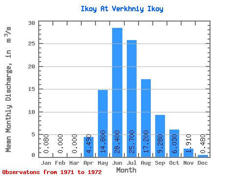
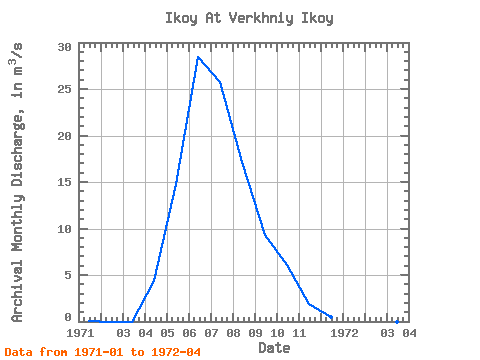
| Statistic | Jan | Feb | Mar | Apr | May | Jun | Jul | Aug | Sep | Oct | Nov | Dec | Annual |
|---|---|---|---|---|---|---|---|---|---|---|---|---|---|
| Mean | 0.08 | 0.00 | 0.00 | 4.49 | 14.80 | 28.40 | 25.70 | 17.20 | 9.28 | 6.03 | 1.91 | 0.48 | 9.02 |
| Standard Deviation | 0.00 | 0.00 | 0.00 | 0.24 | |||||||||
| Min | 0.08 | 0.00 | 0.00 | 4.32 | 14.80 | 28.40 | 25.70 | 17.20 | 9.28 | 6.03 | 1.91 | 0.48 | 9.02 |
| Max | 0.08 | 0.00 | 0.00 | 4.66 | 14.80 | 28.40 | 25.70 | 17.20 | 9.28 | 6.03 | 1.91 | 0.48 | 9.02 |
| Coefficient of Variation | 0.01 | 0.05 |
| Year | Jan | Feb | Mar | Apr | May | Jun | Jul | Aug | Sep | Oct | Nov | Dec | Annual | 1971 | 0.08 | 0.00 | 0.00 | 4.32 | 14.80 | 28.40 | 25.70 | 17.20 | 9.28 | 6.03 | 1.91 | 0.48 | 9.02 | 1972 | 0.08 | 0.00 | 0.00 | 4.66 |
|---|
 Return to R-Arctic Net Home Page